You are here: Home > Network List > TA - USArray Transportable Network (new EarthScope stations) Stations List
> Station Q36A Arnold C. Orvedal, Lecompton, KS, USA > Earthquake Result Viewer
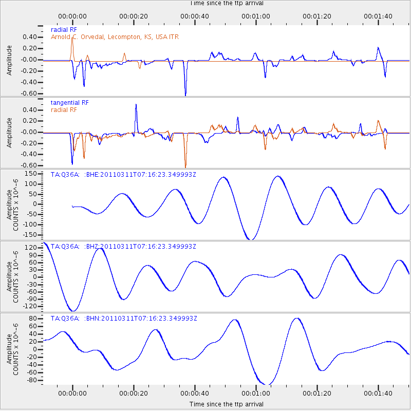
Q36A Arnold C. Orvedal, Lecompton, KS, USA - Earthquake Result Viewer
*The percent match for this event was below the threshold and hence no stack was calculated.
| Earthquake location: |
Near East Coast Of Honshu, Japan |
| Earthquake latitude/longitude: |
39.0/142.4 |
| Earthquake time(UTC): |
2011/03/11 (070) 07:04:16 GMT |
| Earthquake Depth: |
24 km |
| Earthquake Magnitude: |
5.8 MB |
| Earthquake Catalog/Contributor: |
WHDF/NEIC |
|
| Network: |
TA USArray Transportable Network (new EarthScope stations) |
| Station: |
Q36A Arnold C. Orvedal, Lecompton, KS, USA |
| Lat/Lon: |
38.96 N/95.46 W |
| Elevation: |
306 m |
|
| Distance: |
86.1 deg |
| Az: |
41.431 deg |
| Baz: |
318.571 deg |
| Ray Param: |
$rayparam |
*The percent match for this event was below the threshold and hence was not used in the summary stack. |
|
| Radial Match: |
80.26784 % |
| Radial Bump: |
388 |
| Transverse Match: |
85.7455 % |
| Transverse Bump: |
363 |
| SOD ConfigId: |
356183 |
| Insert Time: |
2011-08-11 12:39:56.458 +0000 |
| GWidth: |
2.5 |
| Max Bumps: |
400 |
| Tol: |
0.001 |
|
Signal To Noise
| Channel | StoN | STA | LTA |
| TA:Q36A: :BHZ:20110311T07:16:23.349993Z | 1.3469629 | 1.2402811E-4 | 9.207983E-5 |
| TA:Q36A: :BHN:20110311T07:16:23.349993Z | 0.34729075 | 1.4419754E-5 | 4.1520696E-5 |
| TA:Q36A: :BHE:20110311T07:16:23.349993Z | 1.8672289 | 6.404545E-5 | 3.4299734E-5 |
| Arrivals |
| Ps | |
| PpPs | |
| PsPs/PpSs | |


