You are here: Home > Network List > TA - USArray Transportable Network (new EarthScope stations) Stations List
> Station F33A 5 Mile Ranch, Herman, MN, USA > Earthquake Result Viewer
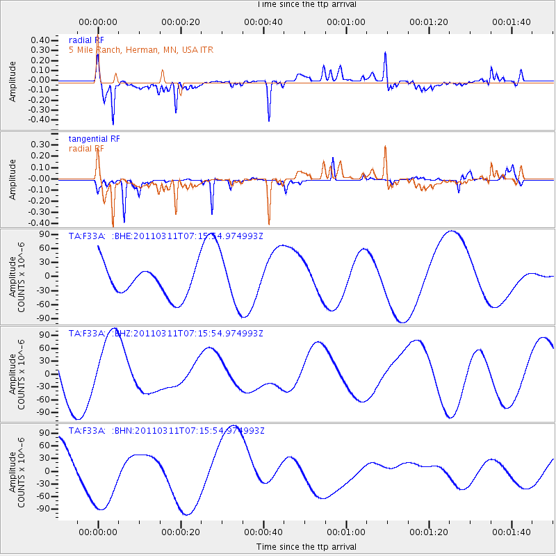
F33A 5 Mile Ranch, Herman, MN, USA - Earthquake Result Viewer
*The percent match for this event was below the threshold and hence no stack was calculated.
| Earthquake location: |
Near East Coast Of Honshu, Japan |
| Earthquake latitude/longitude: |
39.0/142.4 |
| Earthquake time(UTC): |
2011/03/11 (070) 07:04:16 GMT |
| Earthquake Depth: |
24 km |
| Earthquake Magnitude: |
5.8 MB |
| Earthquake Catalog/Contributor: |
WHDF/NEIC |
|
| Network: |
TA USArray Transportable Network (new EarthScope stations) |
| Station: |
F33A 5 Mile Ranch, Herman, MN, USA |
| Lat/Lon: |
45.84 N/96.29 W |
| Elevation: |
313 m |
|
| Distance: |
80.5 deg |
| Az: |
37.267 deg |
| Baz: |
317.524 deg |
| Ray Param: |
$rayparam |
*The percent match for this event was below the threshold and hence was not used in the summary stack. |
|
| Radial Match: |
62.4175 % |
| Radial Bump: |
400 |
| Transverse Match: |
71.151024 % |
| Transverse Bump: |
216 |
| SOD ConfigId: |
356183 |
| Insert Time: |
2011-08-11 12:46:42.887 +0000 |
| GWidth: |
2.5 |
| Max Bumps: |
400 |
| Tol: |
0.001 |
|
Signal To Noise
| Channel | StoN | STA | LTA |
| TA:F33A: :BHZ:20110311T07:15:54.974993Z | 1.0246078 | 8.0446334E-5 | 7.851427E-5 |
| TA:F33A: :BHN:20110311T07:15:54.974993Z | 3.03437 | 9.182925E-5 | 3.0263038E-5 |
| TA:F33A: :BHE:20110311T07:15:54.974993Z | 1.6153563 | 5.1090676E-5 | 3.162812E-5 |
| Arrivals |
| Ps | |
| PpPs | |
| PsPs/PpSs | |


