You are here: Home > Network List > TA - USArray Transportable Network (new EarthScope stations) Stations List
> Station 341A Kurthwood, LA, USA > Earthquake Result Viewer
341A Kurthwood, LA, USA - Earthquake Result Viewer
| Earthquake location: |
Near East Coast Of Honshu, Japan |
| Earthquake latitude/longitude: |
39.0/142.4 |
| Earthquake time(UTC): |
2011/03/11 (070) 07:04:16 GMT |
| Earthquake Depth: |
24 km |
| Earthquake Magnitude: |
5.8 MB |
| Earthquake Catalog/Contributor: |
WHDF/NEIC |
|
| Network: |
TA USArray Transportable Network (new EarthScope stations) |
| Station: |
341A Kurthwood, LA, USA |
| Lat/Lon: |
31.33 N/93.17 W |
| Elevation: |
93 m |
|
| Distance: |
93.0 deg |
| Az: |
44.972 deg |
| Baz: |
319.916 deg |
| Ray Param: |
0.041331973 |
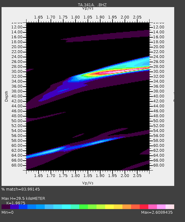
| Estimated Moho Depth: |
29.5 km |
| Estimated Crust Vp/Vs: |
2.00 |
| Assumed Crust Vp: |
6.065 km/s |
| Estimated Crust Vs: |
3.036 km/s |
| Estimated Crust Poisson's Ratio: |
0.33 |
|
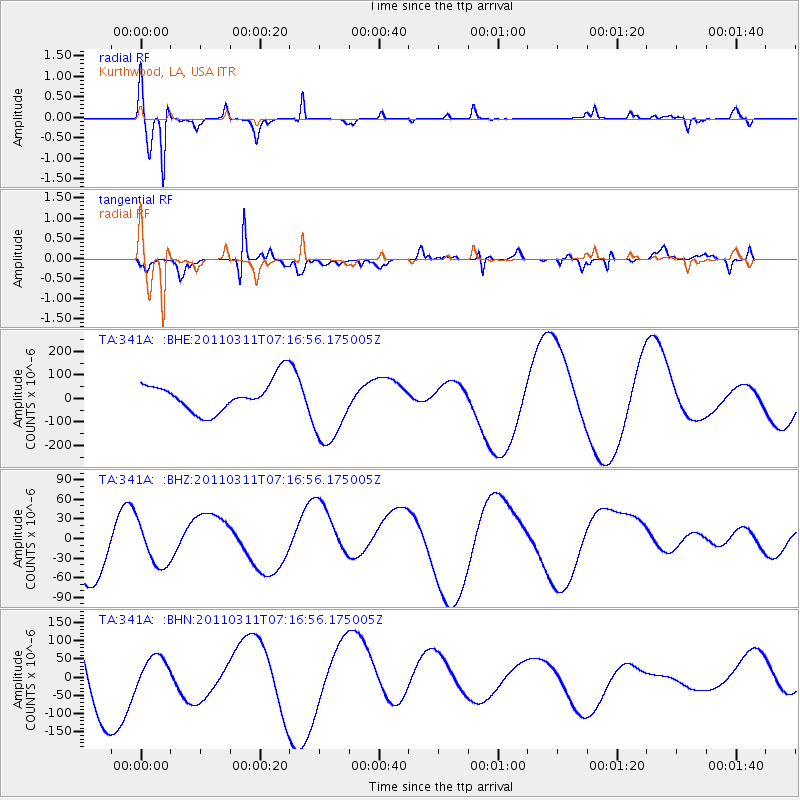
| Radial Match: |
83.99145 % |
| Radial Bump: |
270 |
| Transverse Match: |
53.542183 % |
| Transverse Bump: |
293 |
| SOD ConfigId: |
356183 |
| Insert Time: |
2011-08-11 12:54:54.177 +0000 |
| GWidth: |
2.5 |
| Max Bumps: |
400 |
| Tol: |
0.001 |
|
Signal To Noise
| Channel | StoN | STA | LTA |
| TA:341A: :BHZ:20110311T07:16:56.175005Z | 0.59953517 | 3.05154E-5 | 5.0898434E-5 |
| TA:341A: :BHN:20110311T07:16:56.175005Z | 0.31984732 | 4.3647833E-5 | 1.3646459E-4 |
| TA:341A: :BHE:20110311T07:16:56.175005Z | 2.4719975 | 1.6239568E-4 | 6.569411E-5 |
| Arrivals |
| Ps | 4.9 SECOND |
| PpPs | 14 SECOND |
| PsPs/PpSs | 19 SECOND |


