You are here: Home > Network List > CN - Canadian National Seismograph Network Stations List
> Station INK INUVIK, NT, CANADA.ANADA > Earthquake Result Viewer
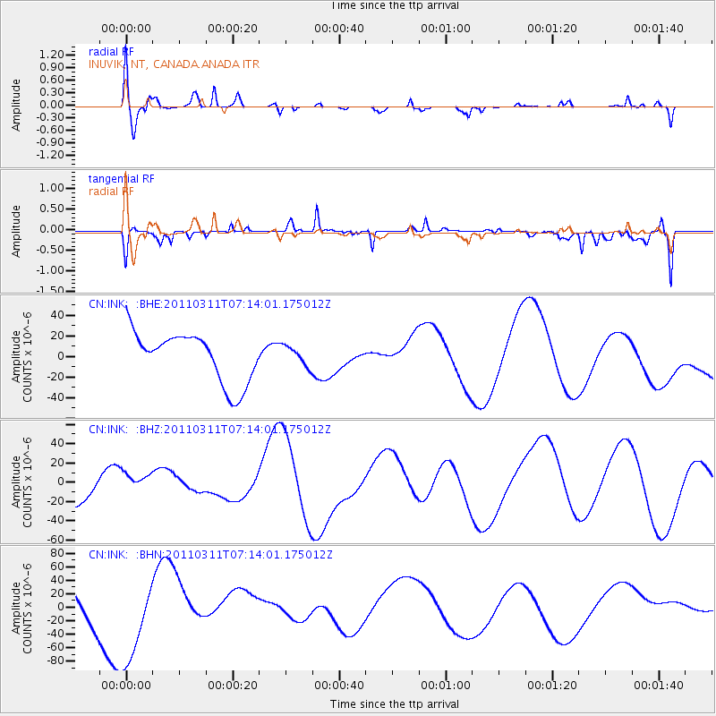
INK INUVIK, NT, CANADA.ANADA - Earthquake Result Viewer
*The percent match for this event was below the threshold and hence no stack was calculated.
| Earthquake location: |
Off East Coast Of Honshu, Japan |
| Earthquake latitude/longitude: |
38.4/143.6 |
| Earthquake time(UTC): |
2011/03/11 (070) 07:05:21 GMT |
| Earthquake Depth: |
15 km |
| Earthquake Magnitude: |
5.7 MB |
| Earthquake Catalog/Contributor: |
WHDF/NEIC |
|
| Network: |
CN Canadian National Seismograph Network |
| Station: |
INK INUVIK, NT, CANADA.ANADA |
| Lat/Lon: |
68.31 N/133.52 W |
| Elevation: |
40 m |
|
| Distance: |
52.3 deg |
| Az: |
27.775 deg |
| Baz: |
280.174 deg |
| Ray Param: |
$rayparam |
*The percent match for this event was below the threshold and hence was not used in the summary stack. |
|
| Radial Match: |
46.354828 % |
| Radial Bump: |
400 |
| Transverse Match: |
65.1718 % |
| Transverse Bump: |
400 |
| SOD ConfigId: |
356183 |
| Insert Time: |
2011-08-11 13:37:08.471 +0000 |
| GWidth: |
2.5 |
| Max Bumps: |
400 |
| Tol: |
0.001 |
|
Signal To Noise
| Channel | StoN | STA | LTA |
| CN:INK: :BHZ:20110311T07:14:01.175012Z | 0.5193515 | 1.1716021E-5 | 2.2558945E-5 |
| CN:INK: :BHN:20110311T07:14:01.175012Z | 2.5490184 | 6.812344E-5 | 2.6725362E-5 |
| CN:INK: :BHE:20110311T07:14:01.175012Z | 0.39307988 | 9.523119E-6 | 2.422693E-5 |
| Arrivals |
| Ps | |
| PpPs | |
| PsPs/PpSs | |


