You are here: Home > Network List > TA - USArray Transportable Network (new EarthScope stations) Stations List
> Station R33A Olander Ranch, Little River, KS, USA > Earthquake Result Viewer
R33A Olander Ranch, Little River, KS, USA - Earthquake Result Viewer
| Earthquake location: |
Off East Coast Of Honshu, Japan |
| Earthquake latitude/longitude: |
38.4/143.6 |
| Earthquake time(UTC): |
2011/03/11 (070) 07:05:21 GMT |
| Earthquake Depth: |
15 km |
| Earthquake Magnitude: |
5.7 MB |
| Earthquake Catalog/Contributor: |
WHDF/NEIC |
|
| Network: |
TA USArray Transportable Network (new EarthScope stations) |
| Station: |
R33A Olander Ranch, Little River, KS, USA |
| Lat/Lon: |
38.31 N/97.98 W |
| Elevation: |
497 m |
|
| Distance: |
84.9 deg |
| Az: |
43.998 deg |
| Baz: |
316.103 deg |
| Ray Param: |
0.045114607 |
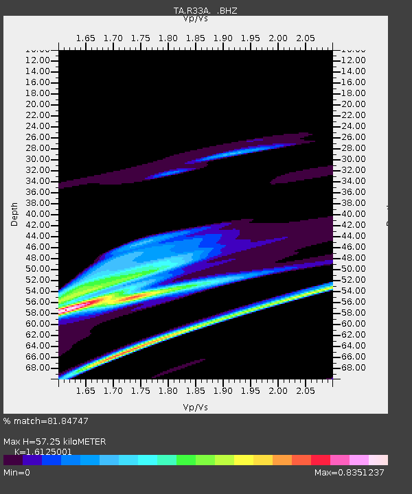
| Estimated Moho Depth: |
57.25 km |
| Estimated Crust Vp/Vs: |
1.61 |
| Assumed Crust Vp: |
6.483 km/s |
| Estimated Crust Vs: |
4.02 km/s |
| Estimated Crust Poisson's Ratio: |
0.19 |
|
| Radial Match: |
81.84747 % |
| Radial Bump: |
400 |
| Transverse Match: |
72.80343 % |
| Transverse Bump: |
243 |
| SOD ConfigId: |
356183 |
| Insert Time: |
2011-08-11 14:13:28.513 +0000 |
| GWidth: |
2.5 |
| Max Bumps: |
400 |
| Tol: |
0.001 |
|

Signal To Noise
| Channel | StoN | STA | LTA |
| TA:R33A: :BHZ:20110311T07:17:23.899988Z | 2.2630584 | 7.371186E-5 | 3.2571792E-5 |
| TA:R33A: :BHN:20110311T07:17:23.899988Z | 0.7757809 | 3.0965824E-5 | 3.991568E-5 |
| TA:R33A: :BHE:20110311T07:17:23.899988Z | 0.41386566 | 1.94254E-5 | 4.693649E-5 |
| Arrivals |
| Ps | 5.6 SECOND |
| PpPs | 22 SECOND |
| PsPs/PpSs | 28 SECOND |


