You are here: Home > Network List > TA - USArray Transportable Network (new EarthScope stations) Stations List
> Station Z35A Perchaven, Sanger, TX, USA > Earthquake Result Viewer
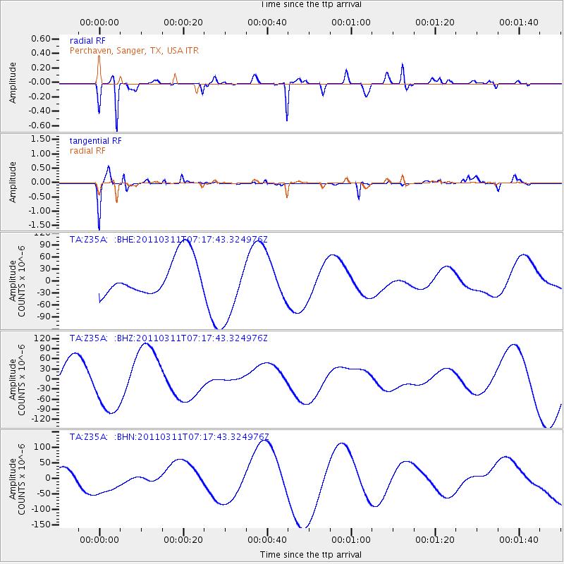
Z35A Perchaven, Sanger, TX, USA - Earthquake Result Viewer
*The percent match for this event was below the threshold and hence no stack was calculated.
| Earthquake location: |
Off East Coast Of Honshu, Japan |
| Earthquake latitude/longitude: |
38.4/143.6 |
| Earthquake time(UTC): |
2011/03/11 (070) 07:05:21 GMT |
| Earthquake Depth: |
15 km |
| Earthquake Magnitude: |
5.7 MB |
| Earthquake Catalog/Contributor: |
WHDF/NEIC |
|
| Network: |
TA USArray Transportable Network (new EarthScope stations) |
| Station: |
Z35A Perchaven, Sanger, TX, USA |
| Lat/Lon: |
33.33 N/97.25 W |
| Elevation: |
235 m |
|
| Distance: |
88.9 deg |
| Az: |
46.997 deg |
| Baz: |
316.69 deg |
| Ray Param: |
$rayparam |
*The percent match for this event was below the threshold and hence was not used in the summary stack. |
|
| Radial Match: |
60.991104 % |
| Radial Bump: |
277 |
| Transverse Match: |
69.35978 % |
| Transverse Bump: |
400 |
| SOD ConfigId: |
356183 |
| Insert Time: |
2011-08-11 14:15:42.019 +0000 |
| GWidth: |
2.5 |
| Max Bumps: |
400 |
| Tol: |
0.001 |
|
Signal To Noise
| Channel | StoN | STA | LTA |
| TA:Z35A: :BHZ:20110311T07:17:43.324976Z | 1.9930578 | 8.791937E-5 | 4.4112803E-5 |
| TA:Z35A: :BHN:20110311T07:17:43.324976Z | 1.9086907 | 4.1127278E-5 | 2.1547377E-5 |
| TA:Z35A: :BHE:20110311T07:17:43.324976Z | 1.7784783 | 8.166379E-5 | 4.591779E-5 |
| Arrivals |
| Ps | |
| PpPs | |
| PsPs/PpSs | |


