You are here: Home > Network List > TA - USArray Transportable Network (new EarthScope stations) Stations List
> Station N34A Lincoln, NE, USA > Earthquake Result Viewer
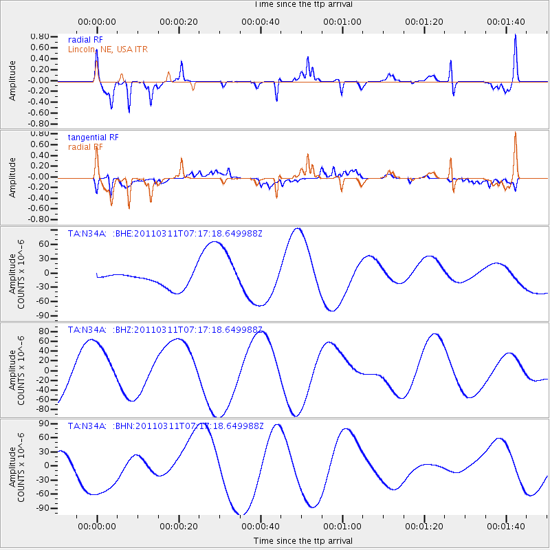
N34A Lincoln, NE, USA - Earthquake Result Viewer
*The percent match for this event was below the threshold and hence no stack was calculated.
| Earthquake location: |
Off East Coast Of Honshu, Japan |
| Earthquake latitude/longitude: |
38.4/143.6 |
| Earthquake time(UTC): |
2011/03/11 (070) 07:05:21 GMT |
| Earthquake Depth: |
15 km |
| Earthquake Magnitude: |
5.7 MB |
| Earthquake Catalog/Contributor: |
WHDF/NEIC |
|
| Network: |
TA USArray Transportable Network (new EarthScope stations) |
| Station: |
N34A Lincoln, NE, USA |
| Lat/Lon: |
40.84 N/96.50 W |
| Elevation: |
401 m |
|
| Distance: |
83.9 deg |
| Az: |
41.414 deg |
| Baz: |
316.794 deg |
| Ray Param: |
$rayparam |
*The percent match for this event was below the threshold and hence was not used in the summary stack. |
|
| Radial Match: |
81.021126 % |
| Radial Bump: |
363 |
| Transverse Match: |
74.75739 % |
| Transverse Bump: |
400 |
| SOD ConfigId: |
356183 |
| Insert Time: |
2011-08-11 14:21:49.509 +0000 |
| GWidth: |
2.5 |
| Max Bumps: |
400 |
| Tol: |
0.001 |
|
Signal To Noise
| Channel | StoN | STA | LTA |
| TA:N34A: :BHZ:20110311T07:17:18.649988Z | 1.1987933 | 5.5067918E-5 | 4.5936125E-5 |
| TA:N34A: :BHN:20110311T07:17:18.649988Z | 4.205106 | 6.46414E-5 | 1.5372123E-5 |
| TA:N34A: :BHE:20110311T07:17:18.649988Z | 3.79448 | 5.6058165E-5 | 1.4773609E-5 |
| Arrivals |
| Ps | |
| PpPs | |
| PsPs/PpSs | |


