You are here: Home > Network List > TA - USArray Transportable Network (new EarthScope stations) Stations List
> Station U37A Salina, OK, USA > Earthquake Result Viewer
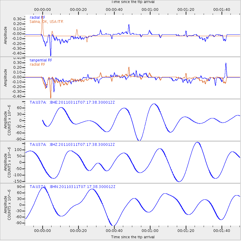
U37A Salina, OK, USA - Earthquake Result Viewer
*The percent match for this event was below the threshold and hence no stack was calculated.
| Earthquake location: |
Off East Coast Of Honshu, Japan |
| Earthquake latitude/longitude: |
38.4/143.6 |
| Earthquake time(UTC): |
2011/03/11 (070) 07:05:21 GMT |
| Earthquake Depth: |
15 km |
| Earthquake Magnitude: |
5.7 MB |
| Earthquake Catalog/Contributor: |
WHDF/NEIC |
|
| Network: |
TA USArray Transportable Network (new EarthScope stations) |
| Station: |
U37A Salina, OK, USA |
| Lat/Lon: |
36.41 N/95.12 W |
| Elevation: |
248 m |
|
| Distance: |
87.9 deg |
| Az: |
43.623 deg |
| Baz: |
317.813 deg |
| Ray Param: |
$rayparam |
*The percent match for this event was below the threshold and hence was not used in the summary stack. |
|
| Radial Match: |
67.9488 % |
| Radial Bump: |
400 |
| Transverse Match: |
55.744175 % |
| Transverse Bump: |
400 |
| SOD ConfigId: |
356183 |
| Insert Time: |
2011-08-11 14:24:57.897 +0000 |
| GWidth: |
2.5 |
| Max Bumps: |
400 |
| Tol: |
0.001 |
|
Signal To Noise
| Channel | StoN | STA | LTA |
| TA:U37A: :BHZ:20110311T07:17:38.300012Z | 1.1652029 | 8.079514E-5 | 6.933997E-5 |
| TA:U37A: :BHN:20110311T07:17:38.300012Z | 2.1739056 | 8.6500106E-5 | 3.9790186E-5 |
| TA:U37A: :BHE:20110311T07:17:38.300012Z | 1.3696216 | 3.9583316E-5 | 2.8900913E-5 |
| Arrivals |
| Ps | |
| PpPs | |
| PsPs/PpSs | |


