You are here: Home > Network List > IU - Global Seismograph Network (GSN - IRIS/USGS) Stations List
> Station HKT Hockley, Texas > Earthquake Result Viewer
HKT Hockley, Texas - Earthquake Result Viewer
| Earthquake location: |
Off East Coast Of Honshu, Japan |
| Earthquake latitude/longitude: |
37.8/143.0 |
| Earthquake time(UTC): |
2011/03/11 (070) 07:06:45 GMT |
| Earthquake Depth: |
22 km |
| Earthquake Magnitude: |
5.6 MB |
| Earthquake Catalog/Contributor: |
WHDF/NEIC |
|
| Network: |
IU Global Seismograph Network (GSN - IRIS/USGS) |
| Station: |
HKT Hockley, Texas |
| Lat/Lon: |
29.96 N/95.84 W |
| Elevation: |
-413.0 m |
|
| Distance: |
93.0 deg |
| Az: |
48.028 deg |
| Baz: |
317.246 deg |
| Ray Param: |
0.04133587 |
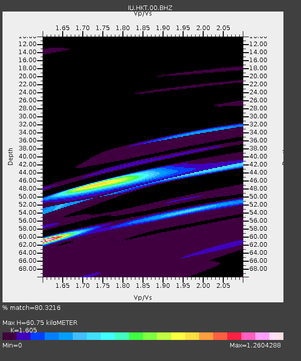
| Estimated Moho Depth: |
60.75 km |
| Estimated Crust Vp/Vs: |
1.61 |
| Assumed Crust Vp: |
5.581 km/s |
| Estimated Crust Vs: |
3.478 km/s |
| Estimated Crust Poisson's Ratio: |
0.18 |
|
| Radial Match: |
80.3216 % |
| Radial Bump: |
400 |
| Transverse Match: |
78.639725 % |
| Transverse Bump: |
400 |
| SOD ConfigId: |
356183 |
| Insert Time: |
2011-08-11 15:34:31.720 +0000 |
| GWidth: |
2.5 |
| Max Bumps: |
400 |
| Tol: |
0.001 |
|
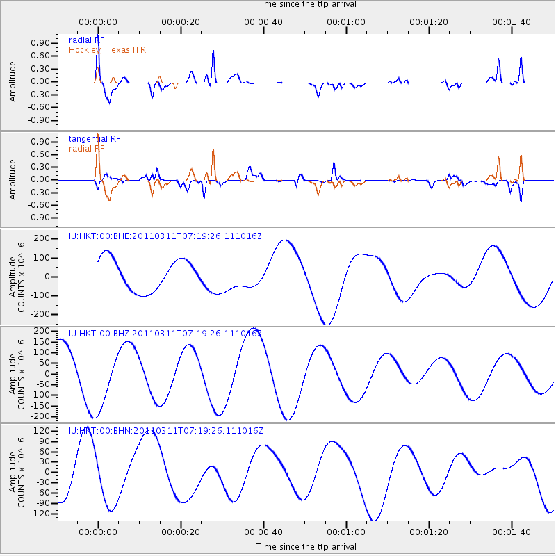
Signal To Noise
| Channel | StoN | STA | LTA |
| IU:HKT:00:BHZ:20110311T07:19:26.111016Z | 1.6382211 | 1.4138117E-4 | 8.630164E-5 |
| IU:HKT:00:BHN:20110311T07:19:26.111016Z | 1.1473777 | 6.6060755E-5 | 5.757542E-5 |
| IU:HKT:00:BHE:20110311T07:19:26.111016Z | 1.0549278 | 8.456586E-5 | 8.016269E-5 |
| Arrivals |
| Ps | 6.7 SECOND |
| PpPs | 28 SECOND |
| PsPs/PpSs | 35 SECOND |


