You are here: Home > Network List > TA - USArray Transportable Network (new EarthScope stations) Stations List
> Station A26A Wade Farm, Kenmare, ND, USA > Earthquake Result Viewer
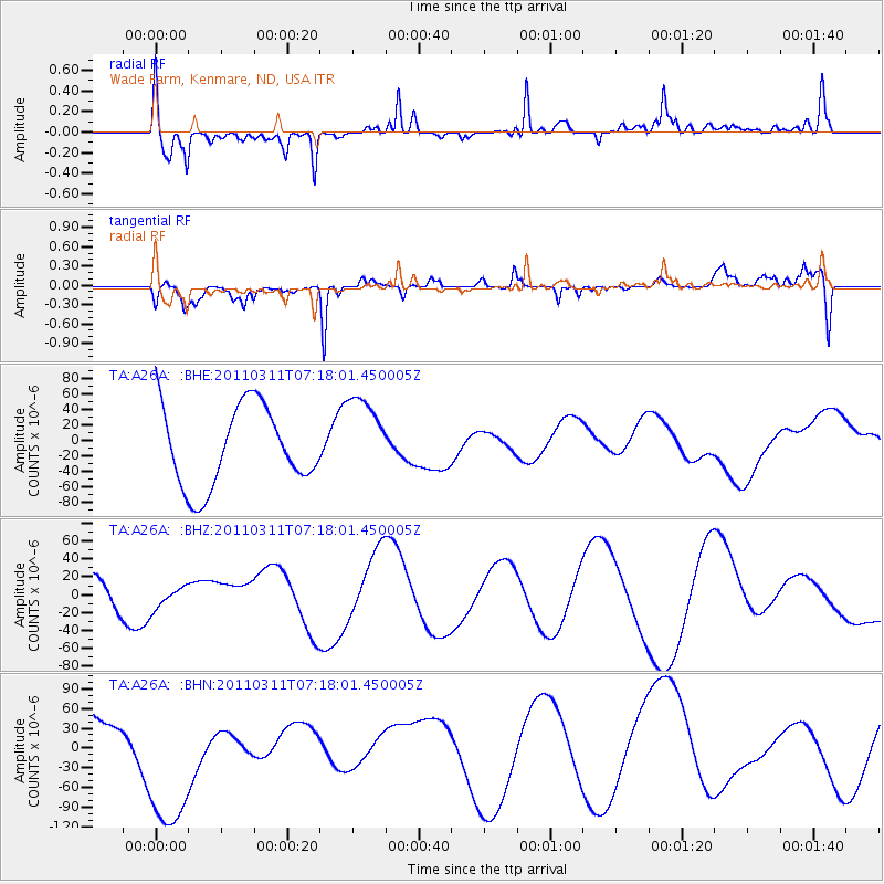
A26A Wade Farm, Kenmare, ND, USA - Earthquake Result Viewer
*The percent match for this event was below the threshold and hence no stack was calculated.
| Earthquake location: |
Off East Coast Of Honshu, Japan |
| Earthquake latitude/longitude: |
37.8/143.0 |
| Earthquake time(UTC): |
2011/03/11 (070) 07:06:45 GMT |
| Earthquake Depth: |
22 km |
| Earthquake Magnitude: |
5.6 MB |
| Earthquake Catalog/Contributor: |
WHDF/NEIC |
|
| Network: |
TA USArray Transportable Network (new EarthScope stations) |
| Station: |
A26A Wade Farm, Kenmare, ND, USA |
| Lat/Lon: |
48.90 N/102.04 W |
| Elevation: |
570 m |
|
| Distance: |
76.3 deg |
| Az: |
38.01 deg |
| Baz: |
312.32 deg |
| Ray Param: |
$rayparam |
*The percent match for this event was below the threshold and hence was not used in the summary stack. |
|
| Radial Match: |
53.399445 % |
| Radial Bump: |
400 |
| Transverse Match: |
68.62827 % |
| Transverse Bump: |
345 |
| SOD ConfigId: |
356183 |
| Insert Time: |
2011-08-11 15:53:54.624 +0000 |
| GWidth: |
2.5 |
| Max Bumps: |
400 |
| Tol: |
0.001 |
|
Signal To Noise
| Channel | StoN | STA | LTA |
| TA:A26A: :BHZ:20110311T07:18:01.450005Z | 0.43302122 | 1.3653989E-5 | 3.1531916E-5 |
| TA:A26A: :BHN:20110311T07:18:01.450005Z | 3.0903287 | 1.287064E-4 | 4.1648123E-5 |
| TA:A26A: :BHE:20110311T07:18:01.450005Z | 1.0471767 | 5.376128E-5 | 5.1339262E-5 |
| Arrivals |
| Ps | |
| PpPs | |
| PsPs/PpSs | |


