You are here: Home > Network List > TA - USArray Transportable Network (new EarthScope stations) Stations List
> Station I37A Lemond, Waseca, MN, USA > Earthquake Result Viewer
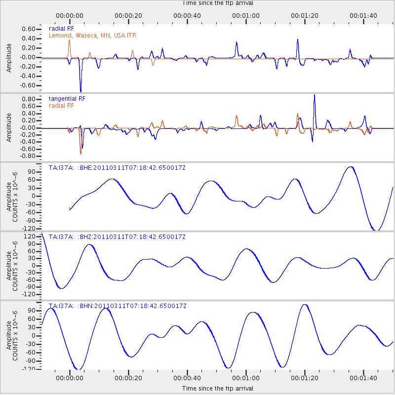
I37A Lemond, Waseca, MN, USA - Earthquake Result Viewer
*The percent match for this event was below the threshold and hence no stack was calculated.
| Earthquake location: |
Off East Coast Of Honshu, Japan |
| Earthquake latitude/longitude: |
37.8/143.0 |
| Earthquake time(UTC): |
2011/03/11 (070) 07:06:45 GMT |
| Earthquake Depth: |
22 km |
| Earthquake Magnitude: |
5.6 MB |
| Earthquake Catalog/Contributor: |
WHDF/NEIC |
|
| Network: |
TA USArray Transportable Network (new EarthScope stations) |
| Station: |
I37A Lemond, Waseca, MN, USA |
| Lat/Lon: |
44.01 N/93.40 W |
| Elevation: |
371 m |
|
| Distance: |
83.9 deg |
| Az: |
37.171 deg |
| Baz: |
318.428 deg |
| Ray Param: |
$rayparam |
*The percent match for this event was below the threshold and hence was not used in the summary stack. |
|
| Radial Match: |
84.19997 % |
| Radial Bump: |
301 |
| Transverse Match: |
78.009346 % |
| Transverse Bump: |
393 |
| SOD ConfigId: |
356183 |
| Insert Time: |
2011-08-11 16:18:59.504 +0000 |
| GWidth: |
2.5 |
| Max Bumps: |
400 |
| Tol: |
0.001 |
|
Signal To Noise
| Channel | StoN | STA | LTA |
| TA:I37A: :BHZ:20110311T07:18:42.650017Z | 0.56729025 | 5.0585477E-5 | 8.917036E-5 |
| TA:I37A: :BHN:20110311T07:18:42.650017Z | 2.3370168 | 1.13762355E-4 | 4.8678452E-5 |
| TA:I37A: :BHE:20110311T07:18:42.650017Z | 0.9355647 | 3.133521E-5 | 3.349337E-5 |
| Arrivals |
| Ps | |
| PpPs | |
| PsPs/PpSs | |


