You are here: Home > Network List > TA - USArray Transportable Network (new EarthScope stations) Stations List
> Station V33A Lossen Ranch, Watonga, OK, USA > Earthquake Result Viewer
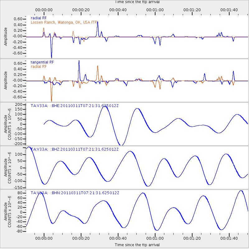
V33A Lossen Ranch, Watonga, OK, USA - Earthquake Result Viewer
*The percent match for this event was below the threshold and hence no stack was calculated.
| Earthquake location: |
Near East Coast Of Honshu, Japan |
| Earthquake latitude/longitude: |
36.7/141.9 |
| Earthquake time(UTC): |
2011/03/11 (070) 07:09:12 GMT |
| Earthquake Depth: |
28 km |
| Earthquake Magnitude: |
5.7 MB |
| Earthquake Catalog/Contributor: |
WHDF/NEIC |
|
| Network: |
TA USArray Transportable Network (new EarthScope stations) |
| Station: |
V33A Lossen Ranch, Watonga, OK, USA |
| Lat/Lon: |
35.82 N/98.29 W |
| Elevation: |
420 m |
|
| Distance: |
88.7 deg |
| Az: |
44.84 deg |
| Baz: |
315.799 deg |
| Ray Param: |
$rayparam |
*The percent match for this event was below the threshold and hence was not used in the summary stack. |
|
| Radial Match: |
90.61619 % |
| Radial Bump: |
179 |
| Transverse Match: |
86.40045 % |
| Transverse Bump: |
381 |
| SOD ConfigId: |
356183 |
| Insert Time: |
2011-08-11 17:39:13.211 +0000 |
| GWidth: |
2.5 |
| Max Bumps: |
400 |
| Tol: |
0.001 |
|
Signal To Noise
| Channel | StoN | STA | LTA |
| TA:V33A: :BHZ:20110311T07:21:31.625012Z | 1.1170043 | 1.1329304E-4 | 1.01425794E-4 |
| TA:V33A: :BHN:20110311T07:21:31.625012Z | 0.9013946 | 4.5967638E-5 | 5.0996132E-5 |
| TA:V33A: :BHE:20110311T07:21:31.625012Z | 3.3910334 | 1.5279706E-4 | 4.5059143E-5 |
| Arrivals |
| Ps | |
| PpPs | |
| PsPs/PpSs | |


