You are here: Home > Network List > TA - USArray Transportable Network (new EarthScope stations) Stations List
> Station K34A Le Mars, IA, USA > Earthquake Result Viewer
K34A Le Mars, IA, USA - Earthquake Result Viewer
| Earthquake location: |
Near East Coast Of Honshu, Japan |
| Earthquake latitude/longitude: |
36.7/141.9 |
| Earthquake time(UTC): |
2011/03/11 (070) 07:09:12 GMT |
| Earthquake Depth: |
28 km |
| Earthquake Magnitude: |
5.7 MB |
| Earthquake Catalog/Contributor: |
WHDF/NEIC |
|
| Network: |
TA USArray Transportable Network (new EarthScope stations) |
| Station: |
K34A Le Mars, IA, USA |
| Lat/Lon: |
42.69 N/96.10 W |
| Elevation: |
436 m |
|
| Distance: |
85.0 deg |
| Az: |
38.867 deg |
| Baz: |
316.853 deg |
| Ray Param: |
0.04507435 |
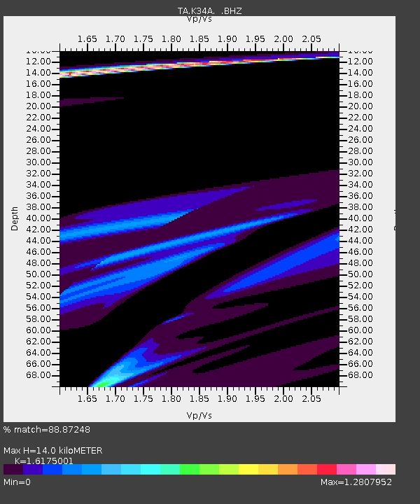
| Estimated Moho Depth: |
14.0 km |
| Estimated Crust Vp/Vs: |
1.62 |
| Assumed Crust Vp: |
6.498 km/s |
| Estimated Crust Vs: |
4.017 km/s |
| Estimated Crust Poisson's Ratio: |
0.19 |
|
| Radial Match: |
88.87248 % |
| Radial Bump: |
400 |
| Transverse Match: |
58.218647 % |
| Transverse Bump: |
317 |
| SOD ConfigId: |
356183 |
| Insert Time: |
2011-08-11 17:48:00.259 +0000 |
| GWidth: |
2.5 |
| Max Bumps: |
400 |
| Tol: |
0.001 |
|

Signal To Noise
| Channel | StoN | STA | LTA |
| TA:K34A: :BHZ:20110311T07:21:13.250012Z | 0.68203205 | 2.45946E-5 | 3.6060766E-5 |
| TA:K34A: :BHN:20110311T07:21:13.250012Z | 1.3015676 | 3.8916372E-5 | 2.9899616E-5 |
| TA:K34A: :BHE:20110311T07:21:13.250012Z | 0.20937523 | 5.721166E-6 | 2.7324942E-5 |
| Arrivals |
| Ps | 1.4 SECOND |
| PpPs | 5.5 SECOND |
| PsPs/PpSs | 6.9 SECOND |


