You are here: Home > Network List > TA - USArray Transportable Network (new EarthScope stations) Stations List
> Station N59A State Game Land 141, Hazleton, PA, USA > Earthquake Result Viewer
N59A State Game Land 141, Hazleton, PA, USA - Earthquake Result Viewer
| Earthquake location: |
Near East Coast Of Honshu, Japan |
| Earthquake latitude/longitude: |
36.7/141.9 |
| Earthquake time(UTC): |
2011/03/11 (070) 07:09:12 GMT |
| Earthquake Depth: |
28 km |
| Earthquake Magnitude: |
5.7 MB |
| Earthquake Catalog/Contributor: |
WHDF/NEIC |
|
| Network: |
TA USArray Transportable Network (new EarthScope stations) |
| Station: |
N59A State Game Land 141, Hazleton, PA, USA |
| Lat/Lon: |
40.92 N/75.77 W |
| Elevation: |
508 m |
|
| Distance: |
95.4 deg |
| Az: |
27.704 deg |
| Baz: |
330.466 deg |
| Ray Param: |
0.04078559 |
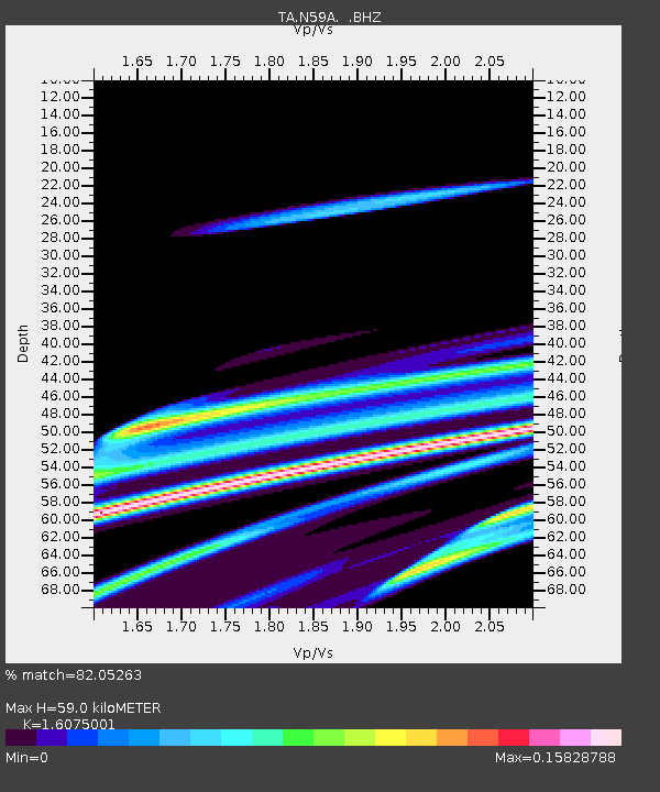
| Estimated Moho Depth: |
59.0 km |
| Estimated Crust Vp/Vs: |
1.61 |
| Assumed Crust Vp: |
6.283 km/s |
| Estimated Crust Vs: |
3.909 km/s |
| Estimated Crust Poisson's Ratio: |
0.18 |
|
| Radial Match: |
82.05263 % |
| Radial Bump: |
265 |
| Transverse Match: |
84.730576 % |
| Transverse Bump: |
383 |
| SOD ConfigId: |
356183 |
| Insert Time: |
2011-08-11 17:55:51.049 +0000 |
| GWidth: |
2.5 |
| Max Bumps: |
400 |
| Tol: |
0.001 |
|
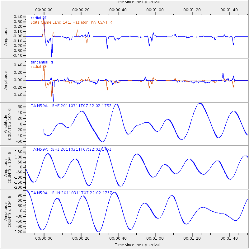
Signal To Noise
| Channel | StoN | STA | LTA |
| TA:N59A: :BHZ:20110311T07:22:02.175Z | 1.6388586 | 1.1350763E-4 | 6.9260175E-5 |
| TA:N59A: :BHN:20110311T07:22:02.175Z | 1.233012 | 7.576011E-5 | 6.144313E-5 |
| TA:N59A: :BHE:20110311T07:22:02.175Z | 2.021911 | 5.2008E-5 | 2.57222E-5 |
| Arrivals |
| Ps | 5.8 SECOND |
| PpPs | 24 SECOND |
| PsPs/PpSs | 30 SECOND |


