You are here: Home > Network List > TA - USArray Transportable Network (new EarthScope stations) Stations List
> Station L37A Phoenix Point, Boone, IA, USA > Earthquake Result Viewer
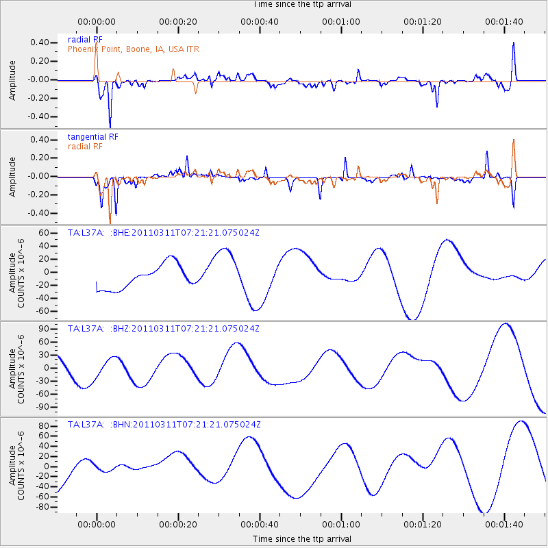
L37A Phoenix Point, Boone, IA, USA - Earthquake Result Viewer
*The percent match for this event was below the threshold and hence no stack was calculated.
| Earthquake location: |
Near East Coast Of Honshu, Japan |
| Earthquake latitude/longitude: |
36.7/141.9 |
| Earthquake time(UTC): |
2011/03/11 (070) 07:09:12 GMT |
| Earthquake Depth: |
28 km |
| Earthquake Magnitude: |
5.7 MB |
| Earthquake Catalog/Contributor: |
WHDF/NEIC |
|
| Network: |
TA USArray Transportable Network (new EarthScope stations) |
| Station: |
L37A Phoenix Point, Boone, IA, USA |
| Lat/Lon: |
42.12 N/93.75 W |
| Elevation: |
312 m |
|
| Distance: |
86.5 deg |
| Az: |
37.963 deg |
| Baz: |
318.36 deg |
| Ray Param: |
$rayparam |
*The percent match for this event was below the threshold and hence was not used in the summary stack. |
|
| Radial Match: |
73.779724 % |
| Radial Bump: |
390 |
| Transverse Match: |
72.721825 % |
| Transverse Bump: |
295 |
| SOD ConfigId: |
356183 |
| Insert Time: |
2011-08-11 17:55:58.155 +0000 |
| GWidth: |
2.5 |
| Max Bumps: |
400 |
| Tol: |
0.001 |
|
Signal To Noise
| Channel | StoN | STA | LTA |
| TA:L37A: :BHZ:20110311T07:21:21.075024Z | 0.52049416 | 2.0648271E-5 | 3.9670515E-5 |
| TA:L37A: :BHN:20110311T07:21:21.075024Z | 0.16510922 | 5.6730037E-6 | 3.43591E-5 |
| TA:L37A: :BHE:20110311T07:21:21.075024Z | 2.0799875 | 3.6629524E-5 | 1.7610455E-5 |
| Arrivals |
| Ps | |
| PpPs | |
| PsPs/PpSs | |


