You are here: Home > Network List > CI - Caltech Regional Seismic Network Stations List
> Station MPM Manuel Prospect Mine, California, USA > Earthquake Result Viewer
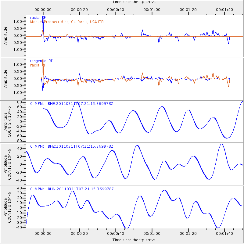
MPM Manuel Prospect Mine, California, USA - Earthquake Result Viewer
*The percent match for this event was below the threshold and hence no stack was calculated.
| Earthquake location: |
Near East Coast Of Honshu, Japan |
| Earthquake latitude/longitude: |
36.7/141.9 |
| Earthquake time(UTC): |
2011/03/11 (070) 07:09:58 GMT |
| Earthquake Depth: |
35 km |
| Earthquake Magnitude: |
5.6 MB |
| Earthquake Catalog/Contributor: |
WHDF/NEIC |
|
| Network: |
CI Caltech Regional Seismic Network |
| Station: |
MPM Manuel Prospect Mine, California, USA |
| Lat/Lon: |
36.06 N/117.49 W |
| Elevation: |
185 m |
|
| Distance: |
76.8 deg |
| Az: |
54.881 deg |
| Baz: |
305.796 deg |
| Ray Param: |
$rayparam |
*The percent match for this event was below the threshold and hence was not used in the summary stack. |
|
| Radial Match: |
75.629036 % |
| Radial Bump: |
389 |
| Transverse Match: |
63.514324 % |
| Transverse Bump: |
285 |
| SOD ConfigId: |
356183 |
| Insert Time: |
2011-08-11 18:32:05.569 +0000 |
| GWidth: |
2.5 |
| Max Bumps: |
400 |
| Tol: |
0.001 |
|
Signal To Noise
| Channel | StoN | STA | LTA |
| CI:MPM: :BHZ:20110311T07:21:15.369978Z | 0.52188677 | 8.948329E-6 | 1.7146112E-5 |
| CI:MPM: :BHN:20110311T07:21:15.369978Z | 0.4103418 | 1.3682364E-5 | 3.3343822E-5 |
| CI:MPM: :BHE:20110311T07:21:15.369978Z | 1.2028123 | 4.4136294E-5 | 3.6694248E-5 |
| Arrivals |
| Ps | |
| PpPs | |
| PsPs/PpSs | |


