You are here: Home > Network List > TA - USArray Transportable Network (new EarthScope stations) Stations List
> Station Q28A Sharon Springs, KS, USA > Earthquake Result Viewer
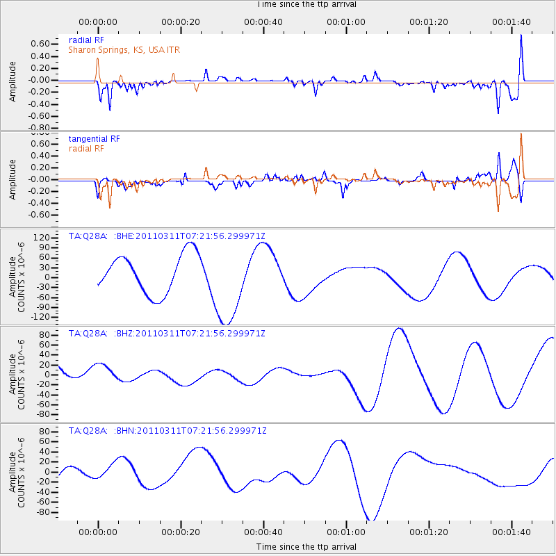
Q28A Sharon Springs, KS, USA - Earthquake Result Viewer
*The percent match for this event was below the threshold and hence no stack was calculated.
| Earthquake location: |
Near East Coast Of Honshu, Japan |
| Earthquake latitude/longitude: |
36.7/141.9 |
| Earthquake time(UTC): |
2011/03/11 (070) 07:09:58 GMT |
| Earthquake Depth: |
35 km |
| Earthquake Magnitude: |
5.6 MB |
| Earthquake Catalog/Contributor: |
WHDF/NEIC |
|
| Network: |
TA USArray Transportable Network (new EarthScope stations) |
| Station: |
Q28A Sharon Springs, KS, USA |
| Lat/Lon: |
39.06 N/101.83 W |
| Elevation: |
1133 m |
|
| Distance: |
84.5 deg |
| Az: |
44.517 deg |
| Baz: |
313.646 deg |
| Ray Param: |
$rayparam |
*The percent match for this event was below the threshold and hence was not used in the summary stack. |
|
| Radial Match: |
55.6183 % |
| Radial Bump: |
377 |
| Transverse Match: |
42.71546 % |
| Transverse Bump: |
347 |
| SOD ConfigId: |
356183 |
| Insert Time: |
2011-08-11 19:01:22.065 +0000 |
| GWidth: |
2.5 |
| Max Bumps: |
400 |
| Tol: |
0.001 |
|
Signal To Noise
| Channel | StoN | STA | LTA |
| TA:Q28A: :BHZ:20110311T07:21:56.299971Z | 0.82208675 | 2.28574E-5 | 2.7804123E-5 |
| TA:Q28A: :BHN:20110311T07:21:56.299971Z | 0.7737016 | 1.9081353E-5 | 2.466242E-5 |
| TA:Q28A: :BHE:20110311T07:21:56.299971Z | 2.2575579 | 1.3075123E-4 | 5.7917114E-5 |
| Arrivals |
| Ps | |
| PpPs | |
| PsPs/PpSs | |


