You are here: Home > Network List > TA - USArray Transportable Network (new EarthScope stations) Stations List
> Station L37A Phoenix Point, Boone, IA, USA > Earthquake Result Viewer
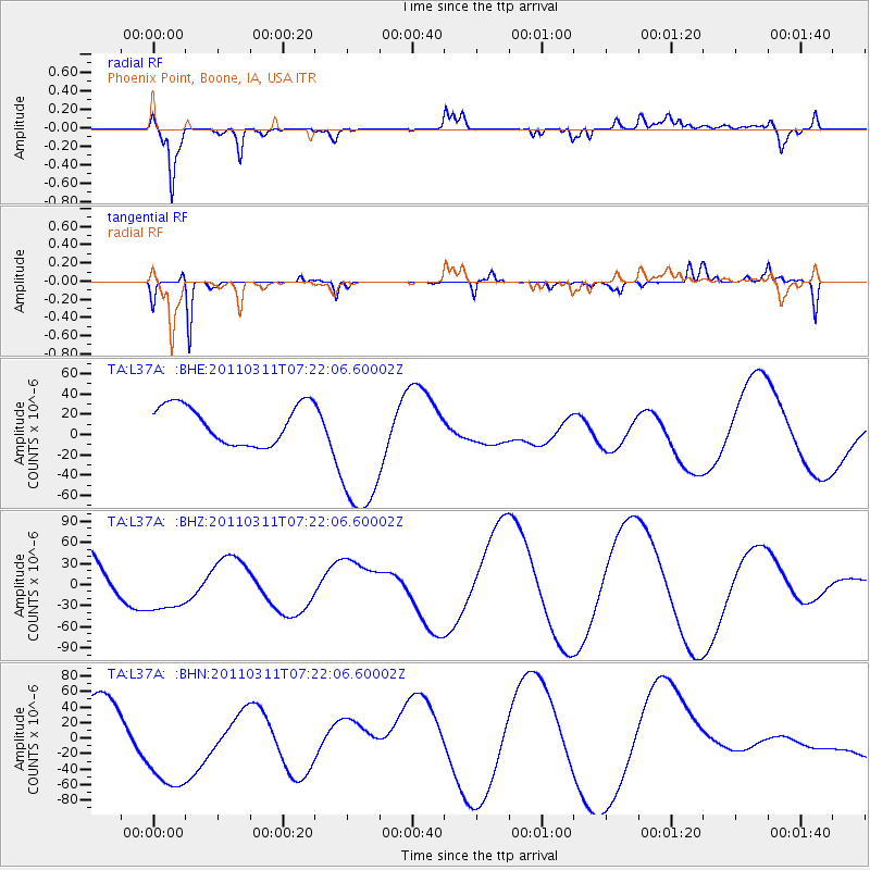
L37A Phoenix Point, Boone, IA, USA - Earthquake Result Viewer
*The percent match for this event was below the threshold and hence no stack was calculated.
| Earthquake location: |
Near East Coast Of Honshu, Japan |
| Earthquake latitude/longitude: |
36.7/141.9 |
| Earthquake time(UTC): |
2011/03/11 (070) 07:09:58 GMT |
| Earthquake Depth: |
35 km |
| Earthquake Magnitude: |
5.6 MB |
| Earthquake Catalog/Contributor: |
WHDF/NEIC |
|
| Network: |
TA USArray Transportable Network (new EarthScope stations) |
| Station: |
L37A Phoenix Point, Boone, IA, USA |
| Lat/Lon: |
42.12 N/93.75 W |
| Elevation: |
312 m |
|
| Distance: |
86.5 deg |
| Az: |
37.953 deg |
| Baz: |
318.373 deg |
| Ray Param: |
$rayparam |
*The percent match for this event was below the threshold and hence was not used in the summary stack. |
|
| Radial Match: |
85.481705 % |
| Radial Bump: |
400 |
| Transverse Match: |
62.73386 % |
| Transverse Bump: |
164 |
| SOD ConfigId: |
356183 |
| Insert Time: |
2011-08-11 19:25:46.118 +0000 |
| GWidth: |
2.5 |
| Max Bumps: |
400 |
| Tol: |
0.001 |
|
Signal To Noise
| Channel | StoN | STA | LTA |
| TA:L37A: :BHZ:20110311T07:22:06.60002Z | 1.3944796 | 4.2038595E-5 | 3.0146439E-5 |
| TA:L37A: :BHN:20110311T07:22:06.60002Z | 2.5057502 | 6.977463E-5 | 2.7845805E-5 |
| TA:L37A: :BHE:20110311T07:22:06.60002Z | 3.873117 | 7.351025E-5 | 1.8979612E-5 |
| Arrivals |
| Ps | |
| PpPs | |
| PsPs/PpSs | |


