You are here: Home > Network List > IU - Global Seismograph Network (GSN - IRIS/USGS) Stations List
> Station HKT Hockley, Texas > Earthquake Result Viewer
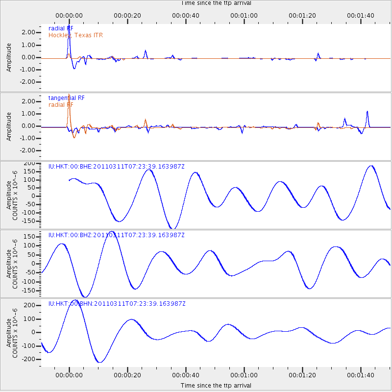
HKT Hockley, Texas - Earthquake Result Viewer

| Earthquake location: |
Off East Coast Of Honshu, Japan |
| Earthquake latitude/longitude: |
37.9/142.7 |
| Earthquake time(UTC): |
2011/03/11 (070) 07:10:59 GMT |
| Earthquake Depth: |
34 km |
| Earthquake Magnitude: |
5.8 MB |
| Earthquake Catalog/Contributor: |
WHDF/NEIC |
|
| Network: |
IU Global Seismograph Network (GSN - IRIS/USGS) |
| Station: |
HKT Hockley, Texas |
| Lat/Lon: |
29.96 N/95.84 W |
| Elevation: |
-413.0 m |
|
| Distance: |
93.1 deg |
| Az: |
47.833 deg |
| Baz: |
317.48 deg |
| Ray Param: |
0.041308377 |
| Estimated Moho Depth: |
55.75 km |
| Estimated Crust Vp/Vs: |
1.67 |
| Assumed Crust Vp: |
5.581 km/s |
| Estimated Crust Vs: |
3.337 km/s |
| Estimated Crust Poisson's Ratio: |
0.22 |
|
| Radial Match: |
81.83391 % |
| Radial Bump: |
400 |
| Transverse Match: |
60.273598 % |
| Transverse Bump: |
400 |
| SOD ConfigId: |
356183 |
| Insert Time: |
2011-08-11 20:08:42.945 +0000 |
| GWidth: |
2.5 |
| Max Bumps: |
400 |
| Tol: |
0.001 |
|
Signal To Noise
| Channel | StoN | STA | LTA |
| IU:HKT:00:BHZ:20110311T07:23:39.163987Z | 2.0515816 | 9.5426876E-5 | 4.6513807E-5 |
| IU:HKT:00:BHN:20110311T07:23:39.163987Z | 2.69287 | 2.221478E-4 | 8.2494815E-5 |
| IU:HKT:00:BHE:20110311T07:23:39.163987Z | 1.213357 | 1.1218895E-4 | 9.246162E-5 |
| Arrivals |
| Ps | 6.8 SECOND |
| PpPs | 26 SECOND |
| PsPs/PpSs | 33 SECOND |


