You are here: Home > Network List > TA - USArray Transportable Network (new EarthScope stations) Stations List
> Station H34A Spellman Lake, Hanley Falls, MN, USA > Earthquake Result Viewer
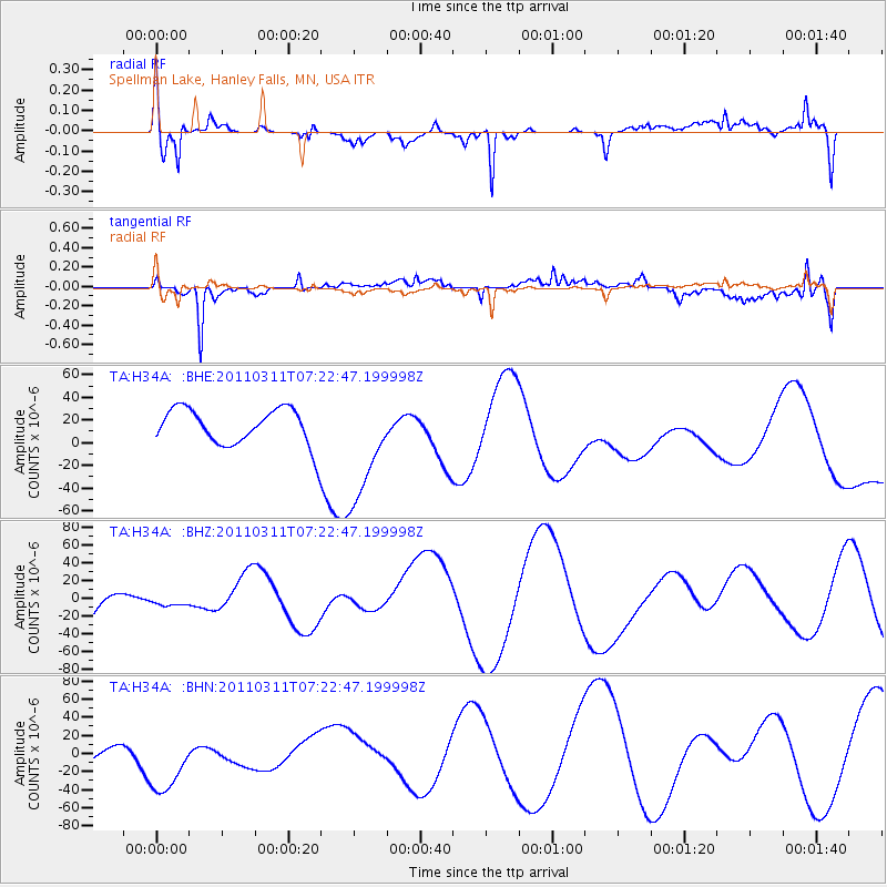
H34A Spellman Lake, Hanley Falls, MN, USA - Earthquake Result Viewer
*The percent match for this event was below the threshold and hence no stack was calculated.
| Earthquake location: |
Off East Coast Of Honshu, Japan |
| Earthquake latitude/longitude: |
37.9/142.7 |
| Earthquake time(UTC): |
2011/03/11 (070) 07:10:59 GMT |
| Earthquake Depth: |
34 km |
| Earthquake Magnitude: |
5.8 MB |
| Earthquake Catalog/Contributor: |
WHDF/NEIC |
|
| Network: |
TA USArray Transportable Network (new EarthScope stations) |
| Station: |
H34A Spellman Lake, Hanley Falls, MN, USA |
| Lat/Lon: |
44.67 N/95.78 W |
| Elevation: |
329 m |
|
| Distance: |
82.4 deg |
| Az: |
37.849 deg |
| Baz: |
317.122 deg |
| Ray Param: |
$rayparam |
*The percent match for this event was below the threshold and hence was not used in the summary stack. |
|
| Radial Match: |
56.784195 % |
| Radial Bump: |
400 |
| Transverse Match: |
69.707855 % |
| Transverse Bump: |
400 |
| SOD ConfigId: |
356183 |
| Insert Time: |
2011-08-11 20:43:47.103 +0000 |
| GWidth: |
2.5 |
| Max Bumps: |
400 |
| Tol: |
0.001 |
|
Signal To Noise
| Channel | StoN | STA | LTA |
| TA:H34A: :BHZ:20110311T07:22:47.199998Z | 0.087093666 | 4.032285E-6 | 4.6298257E-5 |
| TA:H34A: :BHN:20110311T07:22:47.199998Z | 1.6996508 | 4.0494884E-5 | 2.3825416E-5 |
| TA:H34A: :BHE:20110311T07:22:47.199998Z | 3.0768669 | 4.945505E-5 | 1.6073185E-5 |
| Arrivals |
| Ps | |
| PpPs | |
| PsPs/PpSs | |


