You are here: Home > Network List > TA - USArray Transportable Network (new EarthScope stations) Stations List
> Station E33A Westby DABS, Erhard, MN, USA > Earthquake Result Viewer
E33A Westby DABS, Erhard, MN, USA - Earthquake Result Viewer
| Earthquake location: |
Off East Coast Of Honshu, Japan |
| Earthquake latitude/longitude: |
37.9/142.7 |
| Earthquake time(UTC): |
2011/03/11 (070) 07:10:59 GMT |
| Earthquake Depth: |
34 km |
| Earthquake Magnitude: |
5.8 MB |
| Earthquake Catalog/Contributor: |
WHDF/NEIC |
|
| Network: |
TA USArray Transportable Network (new EarthScope stations) |
| Station: |
E33A Westby DABS, Erhard, MN, USA |
| Lat/Lon: |
46.50 N/96.01 W |
| Elevation: |
428 m |
|
| Distance: |
80.9 deg |
| Az: |
36.701 deg |
| Baz: |
316.792 deg |
| Ray Param: |
0.04791339 |
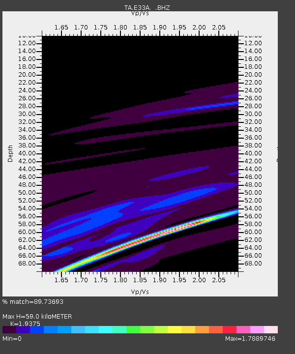
| Estimated Moho Depth: |
59.0 km |
| Estimated Crust Vp/Vs: |
1.94 |
| Assumed Crust Vp: |
6.498 km/s |
| Estimated Crust Vs: |
3.354 km/s |
| Estimated Crust Poisson's Ratio: |
0.32 |
|
| Radial Match: |
89.73693 % |
| Radial Bump: |
378 |
| Transverse Match: |
65.7858 % |
| Transverse Bump: |
312 |
| SOD ConfigId: |
356183 |
| Insert Time: |
2011-08-11 20:46:00.867 +0000 |
| GWidth: |
2.5 |
| Max Bumps: |
400 |
| Tol: |
0.001 |
|
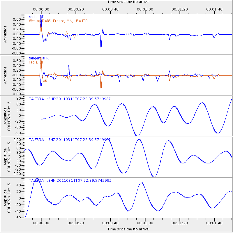
Signal To Noise
| Channel | StoN | STA | LTA |
| TA:E33A: :BHZ:20110311T07:22:39.574998Z | 1.1187048 | 3.527555E-5 | 3.153249E-5 |
| TA:E33A: :BHN:20110311T07:22:39.574998Z | 0.9314175 | 3.2332486E-5 | 3.47132E-5 |
| TA:E33A: :BHE:20110311T07:22:39.574998Z | 6.1677194 | 5.227196E-5 | 8.475087E-6 |
| Arrivals |
| Ps | 8.7 SECOND |
| PpPs | 26 SECOND |
| PsPs/PpSs | 35 SECOND |


