You are here: Home > Network List > TA - USArray Transportable Network (new EarthScope stations) Stations List
> Station J36A Seneca 1, Swea City, IA, USA > Earthquake Result Viewer
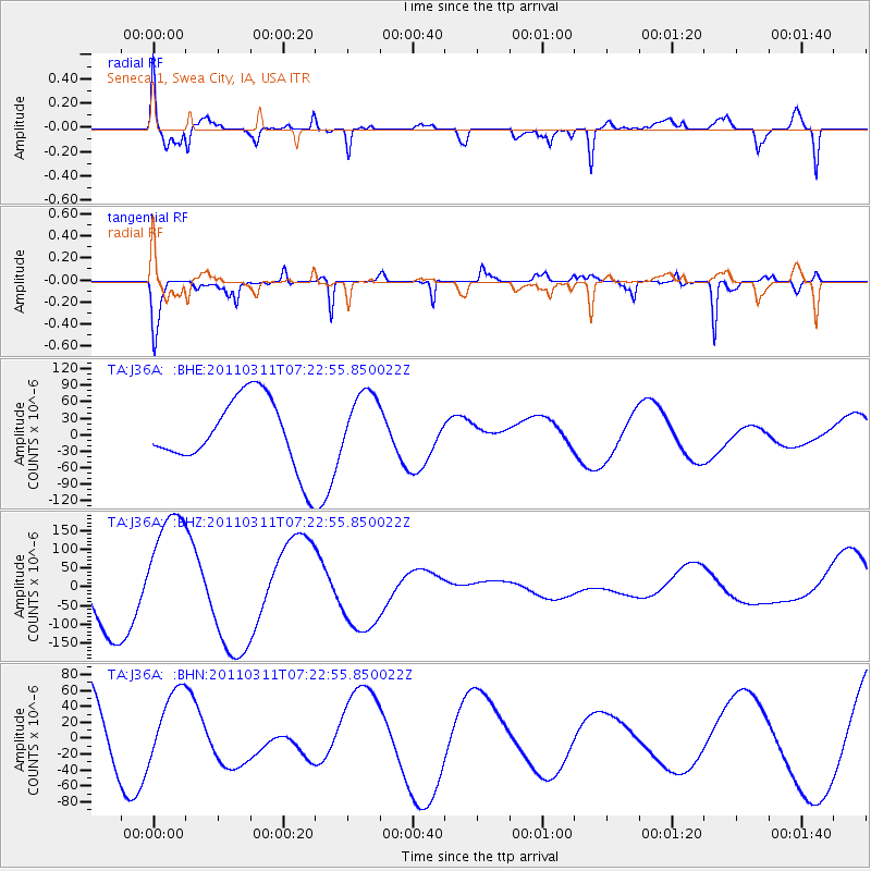
J36A Seneca 1, Swea City, IA, USA - Earthquake Result Viewer

| Earthquake location: |
Off East Coast Of Honshu, Japan |
| Earthquake latitude/longitude: |
37.9/142.7 |
| Earthquake time(UTC): |
2011/03/11 (070) 07:10:59 GMT |
| Earthquake Depth: |
34 km |
| Earthquake Magnitude: |
5.8 MB |
| Earthquake Catalog/Contributor: |
WHDF/NEIC |
|
| Network: |
TA USArray Transportable Network (new EarthScope stations) |
| Station: |
J36A Seneca 1, Swea City, IA, USA |
| Lat/Lon: |
43.33 N/94.34 W |
| Elevation: |
370 m |
|
| Distance: |
84.0 deg |
| Az: |
37.985 deg |
| Baz: |
318.134 deg |
| Ray Param: |
0.045713317 |
| Estimated Moho Depth: |
53.25 km |
| Estimated Crust Vp/Vs: |
1.87 |
| Assumed Crust Vp: |
6.53 km/s |
| Estimated Crust Vs: |
3.497 km/s |
| Estimated Crust Poisson's Ratio: |
0.30 |
|
| Radial Match: |
80.323944 % |
| Radial Bump: |
400 |
| Transverse Match: |
83.68862 % |
| Transverse Bump: |
400 |
| SOD ConfigId: |
356183 |
| Insert Time: |
2011-08-11 20:49:50.347 +0000 |
| GWidth: |
2.5 |
| Max Bumps: |
400 |
| Tol: |
0.001 |
|
Signal To Noise
| Channel | StoN | STA | LTA |
| TA:J36A: :BHZ:20110311T07:22:55.850022Z | 2.6289933 | 1.7078969E-4 | 6.496391E-5 |
| TA:J36A: :BHN:20110311T07:22:55.850022Z | 0.81043756 | 4.7245518E-5 | 5.8296304E-5 |
| TA:J36A: :BHE:20110311T07:22:55.850022Z | 0.9638019 | 6.0220704E-5 | 6.2482446E-5 |
| Arrivals |
| Ps | 7.2 SECOND |
| PpPs | 23 SECOND |
| PsPs/PpSs | 30 SECOND |


