You are here: Home > Network List > TA - USArray Transportable Network (new EarthScope stations) Stations List
> Station H34A Spellman Lake, Hanley Falls, MN, USA > Earthquake Result Viewer
H34A Spellman Lake, Hanley Falls, MN, USA - Earthquake Result Viewer
| Earthquake location: |
Off East Coast Of Honshu, Japan |
| Earthquake latitude/longitude: |
36.1/142.4 |
| Earthquake time(UTC): |
2011/03/11 (070) 07:13:47 GMT |
| Earthquake Depth: |
35 km |
| Earthquake Magnitude: |
5.9 MB |
| Earthquake Catalog/Contributor: |
WHDF/NEIC |
|
| Network: |
TA USArray Transportable Network (new EarthScope stations) |
| Station: |
H34A Spellman Lake, Hanley Falls, MN, USA |
| Lat/Lon: |
44.67 N/95.78 W |
| Elevation: |
329 m |
|
| Distance: |
83.9 deg |
| Az: |
37.55 deg |
| Baz: |
316.237 deg |
| Ray Param: |
0.045797788 |
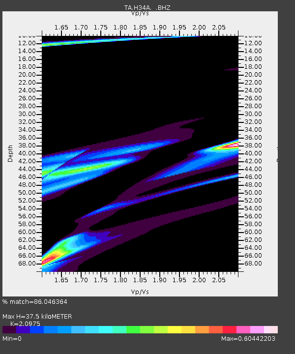
| Estimated Moho Depth: |
37.5 km |
| Estimated Crust Vp/Vs: |
2.10 |
| Assumed Crust Vp: |
6.571 km/s |
| Estimated Crust Vs: |
3.133 km/s |
| Estimated Crust Poisson's Ratio: |
0.35 |
|
| Radial Match: |
86.046364 % |
| Radial Bump: |
367 |
| Transverse Match: |
82.922676 % |
| Transverse Bump: |
284 |
| SOD ConfigId: |
356183 |
| Insert Time: |
2011-08-11 22:16:28.388 +0000 |
| GWidth: |
2.5 |
| Max Bumps: |
400 |
| Tol: |
0.001 |
|
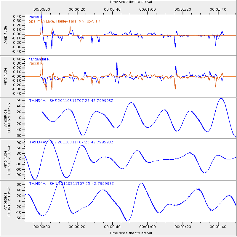
Signal To Noise
| Channel | StoN | STA | LTA |
| TA:H34A: :BHZ:20110311T07:25:42.799993Z | 2.450888 | 7.478135E-5 | 3.0511941E-5 |
| TA:H34A: :BHN:20110311T07:25:42.799993Z | 3.138057 | 4.6912362E-5 | 1.4949493E-5 |
| TA:H34A: :BHE:20110311T07:25:42.799993Z | 0.83589846 | 2.1934737E-5 | 2.624091E-5 |
| Arrivals |
| Ps | 6.4 SECOND |
| PpPs | 17 SECOND |
| PsPs/PpSs | 24 SECOND |


