You are here: Home > Network List > TA - USArray Transportable Network (new EarthScope stations) Stations List
> Station D36A Goodland, MN, USA > Earthquake Result Viewer
D36A Goodland, MN, USA - Earthquake Result Viewer
| Earthquake location: |
Off East Coast Of Honshu, Japan |
| Earthquake latitude/longitude: |
36.1/142.4 |
| Earthquake time(UTC): |
2011/03/11 (070) 07:13:47 GMT |
| Earthquake Depth: |
35 km |
| Earthquake Magnitude: |
5.9 MB |
| Earthquake Catalog/Contributor: |
WHDF/NEIC |
|
| Network: |
TA USArray Transportable Network (new EarthScope stations) |
| Station: |
D36A Goodland, MN, USA |
| Lat/Lon: |
47.18 N/93.16 W |
| Elevation: |
434 m |
|
| Distance: |
83.3 deg |
| Az: |
34.486 deg |
| Baz: |
317.767 deg |
| Ray Param: |
0.04621902 |
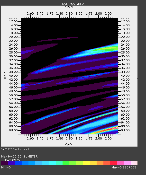
| Estimated Moho Depth: |
66.25 km |
| Estimated Crust Vp/Vs: |
2.10 |
| Assumed Crust Vp: |
6.571 km/s |
| Estimated Crust Vs: |
3.133 km/s |
| Estimated Crust Poisson's Ratio: |
0.35 |
|
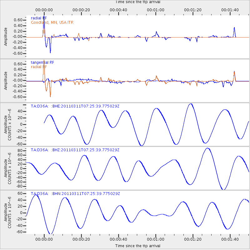
| Radial Match: |
85.37216 % |
| Radial Bump: |
313 |
| Transverse Match: |
33.29017 % |
| Transverse Bump: |
400 |
| SOD ConfigId: |
356183 |
| Insert Time: |
2011-08-11 22:20:36.954 +0000 |
| GWidth: |
2.5 |
| Max Bumps: |
400 |
| Tol: |
0.001 |
|
Signal To Noise
| Channel | StoN | STA | LTA |
| TA:D36A: :BHZ:20110311T07:25:39.775029Z | 0.69674546 | 1.6307353E-5 | 2.3405035E-5 |
| TA:D36A: :BHN:20110311T07:25:39.775029Z | 1.387776 | 4.649368E-5 | 3.3502292E-5 |
| TA:D36A: :BHE:20110311T07:25:39.775029Z | 1.4359063 | 4.0484938E-5 | 2.8194692E-5 |
| Arrivals |
| Ps | 11 SECOND |
| PpPs | 31 SECOND |
| PsPs/PpSs | 42 SECOND |


