You are here: Home > Network List > TA - USArray Transportable Network (new EarthScope stations) Stations List
> Station C36A Pine Crest Fram, Angora, MN, USA > Earthquake Result Viewer
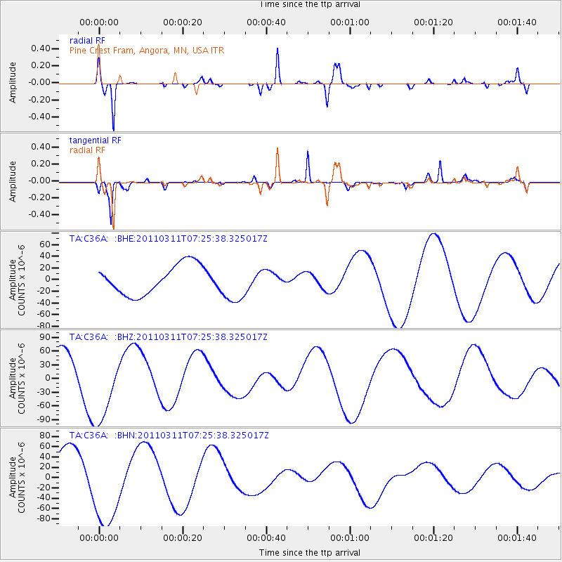
C36A Pine Crest Fram, Angora, MN, USA - Earthquake Result Viewer
*The percent match for this event was below the threshold and hence no stack was calculated.
| Earthquake location: |
Off East Coast Of Honshu, Japan |
| Earthquake latitude/longitude: |
36.1/142.4 |
| Earthquake time(UTC): |
2011/03/11 (070) 07:13:47 GMT |
| Earthquake Depth: |
35 km |
| Earthquake Magnitude: |
5.9 MB |
| Earthquake Catalog/Contributor: |
WHDF/NEIC |
|
| Network: |
TA USArray Transportable Network (new EarthScope stations) |
| Station: |
C36A Pine Crest Fram, Angora, MN, USA |
| Lat/Lon: |
47.76 N/92.84 W |
| Elevation: |
410 m |
|
| Distance: |
83.0 deg |
| Az: |
33.927 deg |
| Baz: |
317.941 deg |
| Ray Param: |
$rayparam |
*The percent match for this event was below the threshold and hence was not used in the summary stack. |
|
| Radial Match: |
84.79491 % |
| Radial Bump: |
343 |
| Transverse Match: |
68.62753 % |
| Transverse Bump: |
219 |
| SOD ConfigId: |
356183 |
| Insert Time: |
2011-08-11 22:22:05.183 +0000 |
| GWidth: |
2.5 |
| Max Bumps: |
400 |
| Tol: |
0.001 |
|
Signal To Noise
| Channel | StoN | STA | LTA |
| TA:C36A: :BHZ:20110311T07:25:38.325017Z | 1.786814 | 8.075997E-5 | 4.519775E-5 |
| TA:C36A: :BHN:20110311T07:25:38.325017Z | 1.8839463 | 8.06701E-5 | 4.2819745E-5 |
| TA:C36A: :BHE:20110311T07:25:38.325017Z | 1.3310944 | 3.3692744E-5 | 2.5312063E-5 |
| Arrivals |
| Ps | |
| PpPs | |
| PsPs/PpSs | |


