You are here: Home > Network List > UW - Pacific Northwest Regional Seismic Network Stations List
> Station HOOD Mt Hood Meadows, OR CREST BB SMO > Earthquake Result Viewer
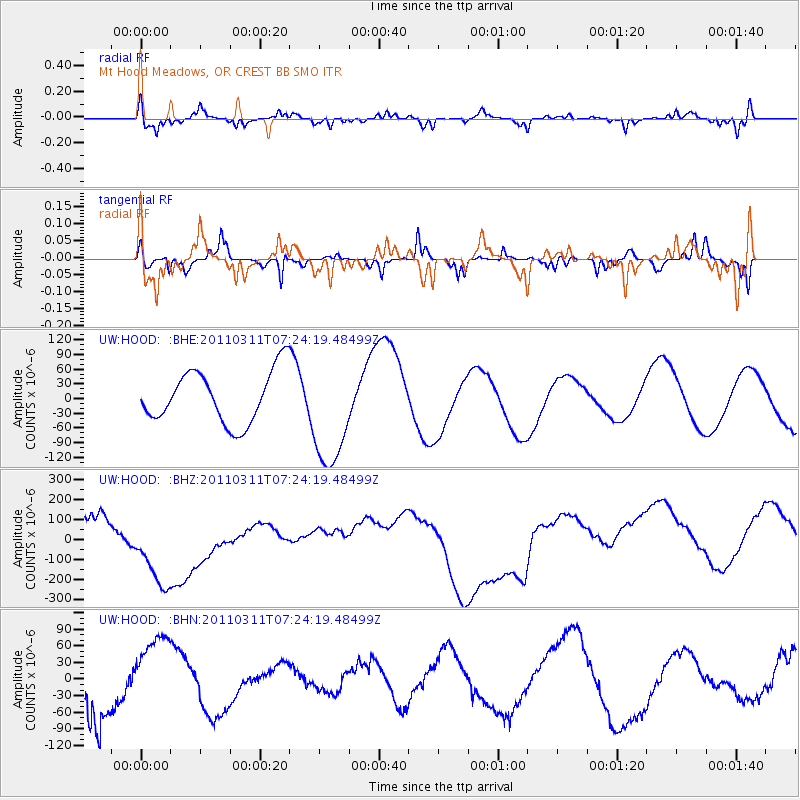
HOOD Mt Hood Meadows, OR CREST BB SMO - Earthquake Result Viewer
*The percent match for this event was below the threshold and hence no stack was calculated.
| Earthquake location: |
Off East Coast Of Honshu, Japan |
| Earthquake latitude/longitude: |
36.1/142.4 |
| Earthquake time(UTC): |
2011/03/11 (070) 07:13:47 GMT |
| Earthquake Depth: |
35 km |
| Earthquake Magnitude: |
5.9 MB |
| Earthquake Catalog/Contributor: |
WHDF/NEIC |
|
| Network: |
UW Pacific Northwest Regional Seismic Network |
| Station: |
HOOD Mt Hood Meadows, OR CREST BB SMO |
| Lat/Lon: |
45.32 N/121.65 W |
| Elevation: |
1520 m |
|
| Distance: |
69.1 deg |
| Az: |
48.668 deg |
| Baz: |
300.465 deg |
| Ray Param: |
$rayparam |
*The percent match for this event was below the threshold and hence was not used in the summary stack. |
|
| Radial Match: |
59.455143 % |
| Radial Bump: |
400 |
| Transverse Match: |
48.874504 % |
| Transverse Bump: |
264 |
| SOD ConfigId: |
356183 |
| Insert Time: |
2011-08-11 22:38:22.485 +0000 |
| GWidth: |
2.5 |
| Max Bumps: |
400 |
| Tol: |
0.001 |
|
Signal To Noise
| Channel | StoN | STA | LTA |
| UW:HOOD: :BHZ:20110311T07:24:19.48499Z | 2.940743 | 2.7802878E-4 | 9.454371E-5 |
| UW:HOOD: :BHN:20110311T07:24:19.48499Z | 2.362965 | 7.587113E-5 | 3.2108444E-5 |
| UW:HOOD: :BHE:20110311T07:24:19.48499Z | 2.1604269 | 1.15048875E-4 | 5.3252847E-5 |
| Arrivals |
| Ps | |
| PpPs | |
| PsPs/PpSs | |


