You are here: Home > Network List > TA - USArray Transportable Network (new EarthScope stations) Stations List
> Station K36A Gilmore City, IA, USA > Earthquake Result Viewer
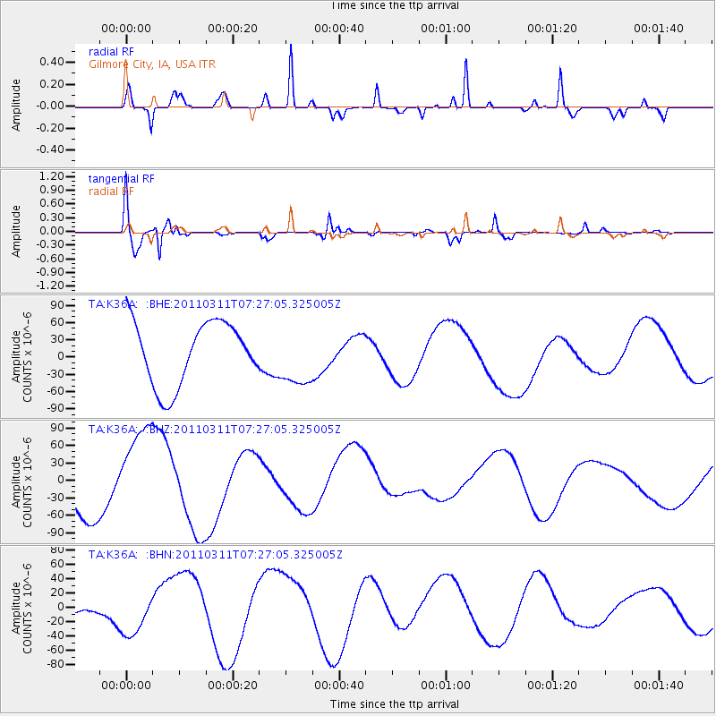
K36A Gilmore City, IA, USA - Earthquake Result Viewer
*The percent match for this event was below the threshold and hence no stack was calculated.
| Earthquake location: |
Near East Coast Of Honshu, Japan |
| Earthquake latitude/longitude: |
36.6/141.8 |
| Earthquake time(UTC): |
2011/03/11 (070) 07:14:58 GMT |
| Earthquake Depth: |
25 km |
| Earthquake Magnitude: |
6.3 MB |
| Earthquake Catalog/Contributor: |
WHDF/NEIC |
|
| Network: |
TA USArray Transportable Network (new EarthScope stations) |
| Station: |
K36A Gilmore City, IA, USA |
| Lat/Lon: |
42.64 N/94.45 W |
| Elevation: |
364 m |
|
| Distance: |
85.9 deg |
| Az: |
37.971 deg |
| Baz: |
317.848 deg |
| Ray Param: |
$rayparam |
*The percent match for this event was below the threshold and hence was not used in the summary stack. |
|
| Radial Match: |
65.07736 % |
| Radial Bump: |
241 |
| Transverse Match: |
82.97952 % |
| Transverse Bump: |
400 |
| SOD ConfigId: |
356183 |
| Insert Time: |
2011-08-12 00:07:41.277 +0000 |
| GWidth: |
2.5 |
| Max Bumps: |
400 |
| Tol: |
0.001 |
|
Signal To Noise
| Channel | StoN | STA | LTA |
| TA:K36A: :BHZ:20110311T07:27:05.325005Z | 2.090466 | 8.412139E-5 | 4.02405E-5 |
| TA:K36A: :BHN:20110311T07:27:05.325005Z | 2.6997786 | 3.4757628E-5 | 1.2874252E-5 |
| TA:K36A: :BHE:20110311T07:27:05.325005Z | 0.95196545 | 5.1950516E-5 | 5.4571854E-5 |
| Arrivals |
| Ps | |
| PpPs | |
| PsPs/PpSs | |


