You are here: Home > Network List > TA - USArray Transportable Network (new EarthScope stations) Stations List
> Station 933A Laredo, TX, USA > Earthquake Result Viewer
933A Laredo, TX, USA - Earthquake Result Viewer
| Earthquake location: |
Off East Coast Of Honshu, Japan |
| Earthquake latitude/longitude: |
37.0/142.4 |
| Earthquake time(UTC): |
2011/03/11 (070) 07:17:42 GMT |
| Earthquake Depth: |
6.3 km |
| Earthquake Magnitude: |
5.8 MB |
| Earthquake Catalog/Contributor: |
WHDF/NEIC |
|
| Network: |
TA USArray Transportable Network (new EarthScope stations) |
| Station: |
933A Laredo, TX, USA |
| Lat/Lon: |
27.61 N/99.27 W |
| Elevation: |
214 m |
|
| Distance: |
93.5 deg |
| Az: |
51.5 deg |
| Baz: |
315.089 deg |
| Ray Param: |
0.04125454 |
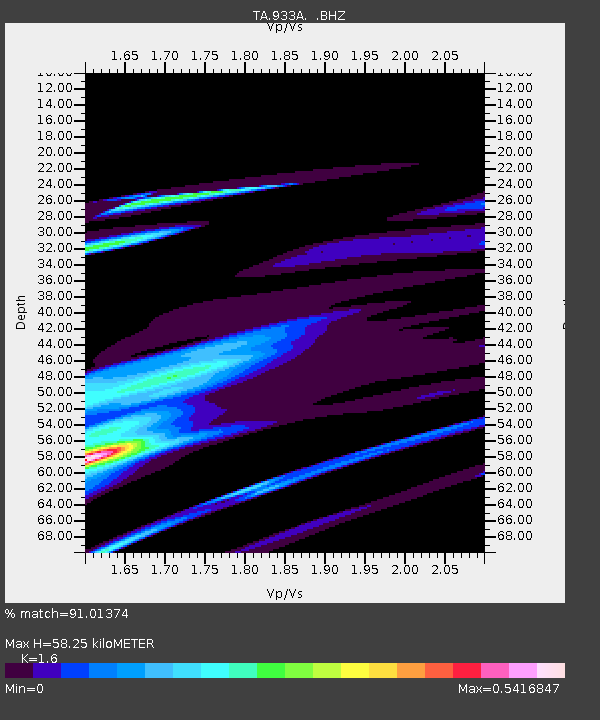
| Estimated Moho Depth: |
58.25 km |
| Estimated Crust Vp/Vs: |
1.60 |
| Assumed Crust Vp: |
6.096 km/s |
| Estimated Crust Vs: |
3.81 km/s |
| Estimated Crust Poisson's Ratio: |
0.18 |
|
| Radial Match: |
91.01374 % |
| Radial Bump: |
400 |
| Transverse Match: |
46.50226 % |
| Transverse Bump: |
400 |
| SOD ConfigId: |
356183 |
| Insert Time: |
2011-08-12 01:23:10.780 +0000 |
| GWidth: |
2.5 |
| Max Bumps: |
400 |
| Tol: |
0.001 |
|

Signal To Noise
| Channel | StoN | STA | LTA |
| TA:933A: :BHZ:20110311T07:30:27.424978Z | 0.29137722 | 1.7390215E-5 | 5.968283E-5 |
| TA:933A: :BHN:20110311T07:30:27.424978Z | 1.171148 | 8.378117E-5 | 7.1537645E-5 |
| TA:933A: :BHE:20110311T07:30:27.424978Z | 1.7046093 | 1.4298876E-4 | 8.38836E-5 |
| Arrivals |
| Ps | 5.9 SECOND |
| PpPs | 24 SECOND |
| PsPs/PpSs | 30 SECOND |


