You are here: Home > Network List > TA - USArray Transportable Network (new EarthScope stations) Stations List
> Station G32A Webster, SD, USA > Earthquake Result Viewer
G32A Webster, SD, USA - Earthquake Result Viewer
| Earthquake location: |
Off East Coast Of Honshu, Japan |
| Earthquake latitude/longitude: |
37.0/142.4 |
| Earthquake time(UTC): |
2011/03/11 (070) 07:17:42 GMT |
| Earthquake Depth: |
6.3 km |
| Earthquake Magnitude: |
5.8 MB |
| Earthquake Catalog/Contributor: |
WHDF/NEIC |
|
| Network: |
TA USArray Transportable Network (new EarthScope stations) |
| Station: |
G32A Webster, SD, USA |
| Lat/Lon: |
45.26 N/97.50 W |
| Elevation: |
566 m |
|
| Distance: |
81.9 deg |
| Az: |
38.116 deg |
| Baz: |
315.608 deg |
| Ray Param: |
0.047261678 |
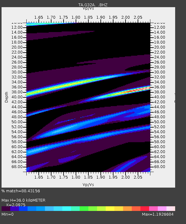
| Estimated Moho Depth: |
36.0 km |
| Estimated Crust Vp/Vs: |
2.10 |
| Assumed Crust Vp: |
6.552 km/s |
| Estimated Crust Vs: |
3.124 km/s |
| Estimated Crust Poisson's Ratio: |
0.35 |
|
| Radial Match: |
88.43156 % |
| Radial Bump: |
365 |
| Transverse Match: |
56.882473 % |
| Transverse Bump: |
400 |
| SOD ConfigId: |
356183 |
| Insert Time: |
2011-08-12 01:30:47.519 +0000 |
| GWidth: |
2.5 |
| Max Bumps: |
400 |
| Tol: |
0.001 |
|

Signal To Noise
| Channel | StoN | STA | LTA |
| TA:G32A: :BHZ:20110311T07:29:31.549978Z | 1.5104927 | 4.9687616E-5 | 3.289497E-5 |
| TA:G32A: :BHN:20110311T07:29:31.549978Z | 2.1889164 | 5.138332E-5 | 2.3474318E-5 |
| TA:G32A: :BHE:20110311T07:29:31.549978Z | 0.86261636 | 2.367046E-5 | 2.7440308E-5 |
| Arrivals |
| Ps | 6.2 SECOND |
| PpPs | 17 SECOND |
| PsPs/PpSs | 23 SECOND |


