You are here: Home > Network List > TA - USArray Transportable Network (new EarthScope stations) Stations List
> Station E36A McGregor, MN, USA > Earthquake Result Viewer
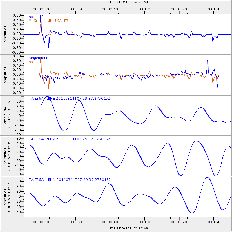
E36A McGregor, MN, USA - Earthquake Result Viewer
*The percent match for this event was below the threshold and hence no stack was calculated.
| Earthquake location: |
Off East Coast Of Honshu, Japan |
| Earthquake latitude/longitude: |
37.0/142.4 |
| Earthquake time(UTC): |
2011/03/11 (070) 07:17:42 GMT |
| Earthquake Depth: |
6.3 km |
| Earthquake Magnitude: |
5.8 MB |
| Earthquake Catalog/Contributor: |
WHDF/NEIC |
|
| Network: |
TA USArray Transportable Network (new EarthScope stations) |
| Station: |
E36A McGregor, MN, USA |
| Lat/Lon: |
46.52 N/93.26 W |
| Elevation: |
393 m |
|
| Distance: |
83.0 deg |
| Az: |
35.063 deg |
| Baz: |
318.245 deg |
| Ray Param: |
$rayparam |
*The percent match for this event was below the threshold and hence was not used in the summary stack. |
|
| Radial Match: |
72.59547 % |
| Radial Bump: |
400 |
| Transverse Match: |
64.301704 % |
| Transverse Bump: |
400 |
| SOD ConfigId: |
356183 |
| Insert Time: |
2011-08-12 01:32:48.773 +0000 |
| GWidth: |
2.5 |
| Max Bumps: |
400 |
| Tol: |
0.001 |
|
Signal To Noise
| Channel | StoN | STA | LTA |
| TA:E36A: :BHZ:20110311T07:29:37.275015Z | 1.0258856 | 2.8302966E-5 | 2.7588812E-5 |
| TA:E36A: :BHN:20110311T07:29:37.275015Z | 4.9342437 | 4.3567878E-5 | 8.829697E-6 |
| TA:E36A: :BHE:20110311T07:29:37.275015Z | 1.3388301 | 6.650369E-5 | 4.9672988E-5 |
| Arrivals |
| Ps | |
| PpPs | |
| PsPs/PpSs | |


