You are here: Home > Network List > TA - USArray Transportable Network (new EarthScope stations) Stations List
> Station Y37A Hugo, OK, USA > Earthquake Result Viewer
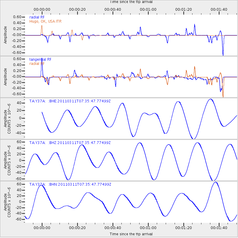
Y37A Hugo, OK, USA - Earthquake Result Viewer
*The percent match for this event was below the threshold and hence no stack was calculated.
| Earthquake location: |
Off East Coast Of Honshu, Japan |
| Earthquake latitude/longitude: |
37.5/142.1 |
| Earthquake time(UTC): |
2011/03/11 (070) 07:23:16 GMT |
| Earthquake Depth: |
20 km |
| Earthquake Magnitude: |
5.9 MB |
| Earthquake Catalog/Contributor: |
WHDF/NEIC |
|
| Network: |
TA USArray Transportable Network (new EarthScope stations) |
| Station: |
Y37A Hugo, OK, USA |
| Lat/Lon: |
33.98 N/95.62 W |
| Elevation: |
165 m |
|
| Distance: |
90.9 deg |
| Az: |
44.638 deg |
| Baz: |
317.71 deg |
| Ray Param: |
$rayparam |
*The percent match for this event was below the threshold and hence was not used in the summary stack. |
|
| Radial Match: |
48.648396 % |
| Radial Bump: |
335 |
| Transverse Match: |
59.06006 % |
| Transverse Bump: |
275 |
| SOD ConfigId: |
356183 |
| Insert Time: |
2011-08-12 02:54:49.544 +0000 |
| GWidth: |
2.5 |
| Max Bumps: |
400 |
| Tol: |
0.001 |
|
Signal To Noise
| Channel | StoN | STA | LTA |
| TA:Y37A: :BHZ:20110311T07:35:47.77499Z | 0.13551356 | 5.9811714E-6 | 4.4137072E-5 |
| TA:Y37A: :BHN:20110311T07:35:47.77499Z | 1.8903463 | 5.081872E-5 | 2.6883285E-5 |
| TA:Y37A: :BHE:20110311T07:35:47.77499Z | 1.742765 | 3.145856E-5 | 1.8050947E-5 |
| Arrivals |
| Ps | |
| PpPs | |
| PsPs/PpSs | |


