You are here: Home > Network List > IU - Global Seismograph Network (GSN - IRIS/USGS) Stations List
> Station FURI Mt. Furi, Ethiopia > Earthquake Result Viewer
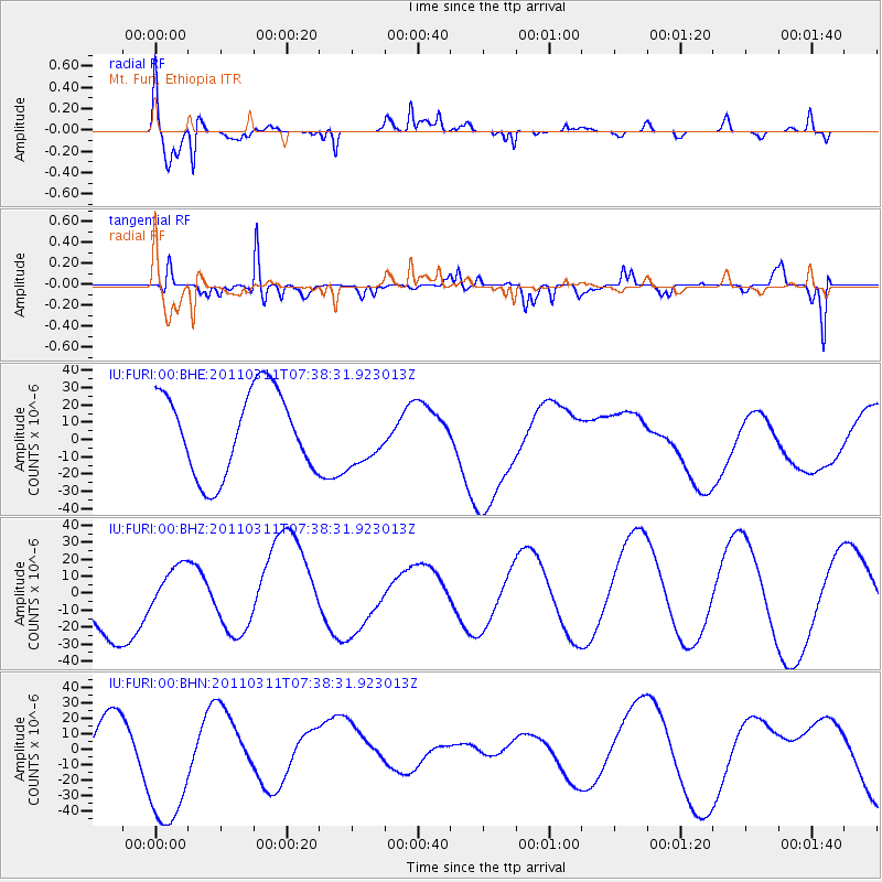
FURI Mt. Furi, Ethiopia - Earthquake Result Viewer
*The percent match for this event was below the threshold and hence no stack was calculated.
| Earthquake location: |
Off East Coast Of Honshu, Japan |
| Earthquake latitude/longitude: |
37.9/144.5 |
| Earthquake time(UTC): |
2011/03/11 (070) 07:25:36 GMT |
| Earthquake Depth: |
40 km |
| Earthquake Magnitude: |
6.1 MB |
| Earthquake Catalog/Contributor: |
WHDF/NEIC |
|
| Network: |
IU Global Seismograph Network (GSN - IRIS/USGS) |
| Station: |
FURI Mt. Furi, Ethiopia |
| Lat/Lon: |
8.90 N/38.68 E |
| Elevation: |
2570 m |
|
| Distance: |
96.9 deg |
| Az: |
286.782 deg |
| Baz: |
50.008 deg |
| Ray Param: |
$rayparam |
*The percent match for this event was below the threshold and hence was not used in the summary stack. |
|
| Radial Match: |
59.057312 % |
| Radial Bump: |
400 |
| Transverse Match: |
60.466263 % |
| Transverse Bump: |
298 |
| SOD ConfigId: |
356183 |
| Insert Time: |
2011-08-12 03:58:02.013 +0000 |
| GWidth: |
2.5 |
| Max Bumps: |
400 |
| Tol: |
0.001 |
|
Signal To Noise
| Channel | StoN | STA | LTA |
| IU:FURI:00:BHZ:20110311T07:38:31.923013Z | 0.6981086 | 1.2248328E-5 | 1.7545019E-5 |
| IU:FURI:00:BHN:20110311T07:38:31.923013Z | 1.9598551 | 4.8045953E-5 | 2.4515055E-5 |
| IU:FURI:00:BHE:20110311T07:38:31.923013Z | 0.6829669 | 1.6256328E-5 | 2.3802513E-5 |
| Arrivals |
| Ps | |
| PpPs | |
| PsPs/PpSs | |


