You are here: Home > Network List > TA - USArray Transportable Network (new EarthScope stations) Stations List
> Station 234A Clairette, TX, USA > Earthquake Result Viewer
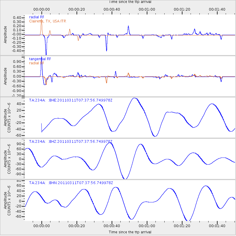
234A Clairette, TX, USA - Earthquake Result Viewer
*The percent match for this event was below the threshold and hence no stack was calculated.
| Earthquake location: |
Off East Coast Of Honshu, Japan |
| Earthquake latitude/longitude: |
37.9/144.5 |
| Earthquake time(UTC): |
2011/03/11 (070) 07:25:36 GMT |
| Earthquake Depth: |
40 km |
| Earthquake Magnitude: |
6.1 MB |
| Earthquake Catalog/Contributor: |
WHDF/NEIC |
|
| Network: |
TA USArray Transportable Network (new EarthScope stations) |
| Station: |
234A Clairette, TX, USA |
| Lat/Lon: |
32.00 N/98.14 W |
| Elevation: |
358 m |
|
| Distance: |
89.2 deg |
| Az: |
49.01 deg |
| Baz: |
315.372 deg |
| Ray Param: |
$rayparam |
*The percent match for this event was below the threshold and hence was not used in the summary stack. |
|
| Radial Match: |
81.22137 % |
| Radial Bump: |
241 |
| Transverse Match: |
75.23206 % |
| Transverse Bump: |
400 |
| SOD ConfigId: |
356183 |
| Insert Time: |
2011-08-12 04:31:21.319 +0000 |
| GWidth: |
2.5 |
| Max Bumps: |
400 |
| Tol: |
0.001 |
|
Signal To Noise
| Channel | StoN | STA | LTA |
| TA:234A: :BHZ:20110311T07:37:56.749978Z | 0.660192 | 3.9204053E-5 | 5.93828E-5 |
| TA:234A: :BHN:20110311T07:37:56.749978Z | 0.5348215 | 2.0108031E-5 | 3.7597645E-5 |
| TA:234A: :BHE:20110311T07:37:56.749978Z | 4.174425 | 5.140265E-5 | 1.2313708E-5 |
| Arrivals |
| Ps | |
| PpPs | |
| PsPs/PpSs | |


