You are here: Home > Network List > TA - USArray Transportable Network (new EarthScope stations) Stations List
> Station 633A Saathoff Ranch, Hondo, TX, USA > Earthquake Result Viewer
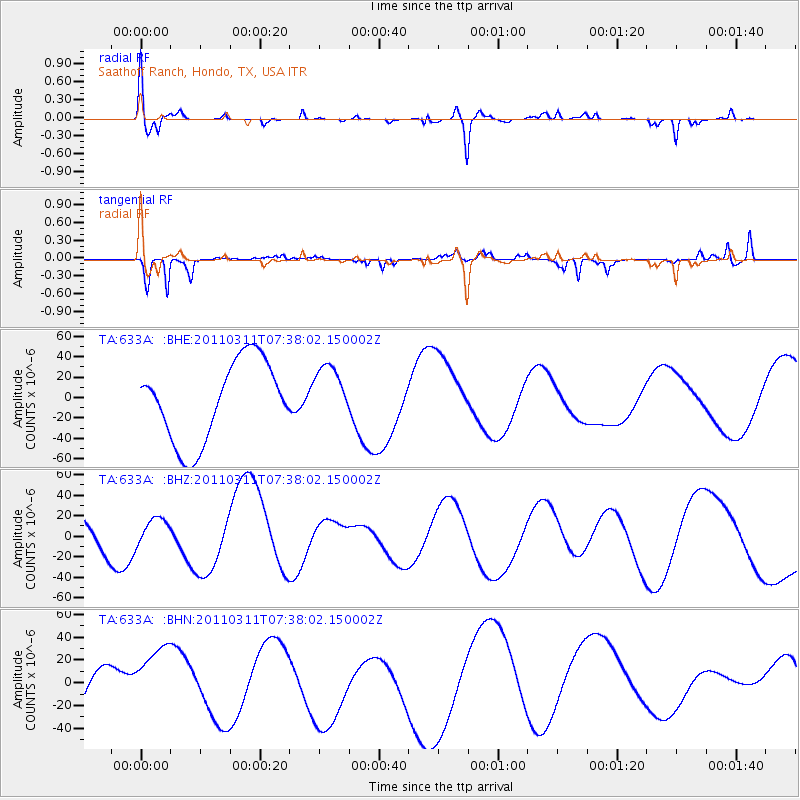
633A Saathoff Ranch, Hondo, TX, USA - Earthquake Result Viewer
*The percent match for this event was below the threshold and hence no stack was calculated.
| Earthquake location: |
Off East Coast Of Honshu, Japan |
| Earthquake latitude/longitude: |
37.9/144.5 |
| Earthquake time(UTC): |
2011/03/11 (070) 07:25:36 GMT |
| Earthquake Depth: |
40 km |
| Earthquake Magnitude: |
6.1 MB |
| Earthquake Catalog/Contributor: |
WHDF/NEIC |
|
| Network: |
TA USArray Transportable Network (new EarthScope stations) |
| Station: |
633A Saathoff Ranch, Hondo, TX, USA |
| Lat/Lon: |
29.46 N/99.18 W |
| Elevation: |
320 m |
|
| Distance: |
90.3 deg |
| Az: |
51.434 deg |
| Baz: |
314.853 deg |
| Ray Param: |
$rayparam |
*The percent match for this event was below the threshold and hence was not used in the summary stack. |
|
| Radial Match: |
66.576485 % |
| Radial Bump: |
400 |
| Transverse Match: |
46.80348 % |
| Transverse Bump: |
236 |
| SOD ConfigId: |
356183 |
| Insert Time: |
2011-08-12 04:31:49.645 +0000 |
| GWidth: |
2.5 |
| Max Bumps: |
400 |
| Tol: |
0.001 |
|
Signal To Noise
| Channel | StoN | STA | LTA |
| TA:633A: :BHZ:20110311T07:38:02.150002Z | 0.70116955 | 1.3073631E-5 | 1.8645464E-5 |
| TA:633A: :BHN:20110311T07:38:02.150002Z | 1.3711324 | 3.363364E-5 | 2.4529829E-5 |
| TA:633A: :BHE:20110311T07:38:02.150002Z | 0.6969922 | 2.7204409E-5 | 3.9031154E-5 |
| Arrivals |
| Ps | |
| PpPs | |
| PsPs/PpSs | |


