You are here: Home > Network List > TA - USArray Transportable Network (new EarthScope stations) Stations List
> Station 336A Riesel, TX, USA > Earthquake Result Viewer
336A Riesel, TX, USA - Earthquake Result Viewer
| Earthquake location: |
Off East Coast Of Honshu, Japan |
| Earthquake latitude/longitude: |
37.9/144.5 |
| Earthquake time(UTC): |
2011/03/11 (070) 07:25:36 GMT |
| Earthquake Depth: |
40 km |
| Earthquake Magnitude: |
6.1 MB |
| Earthquake Catalog/Contributor: |
WHDF/NEIC |
|
| Network: |
TA USArray Transportable Network (new EarthScope stations) |
| Station: |
336A Riesel, TX, USA |
| Lat/Lon: |
31.39 N/96.84 W |
| Elevation: |
140 m |
|
| Distance: |
90.4 deg |
| Az: |
48.65 deg |
| Baz: |
316.047 deg |
| Ray Param: |
0.04167182 |
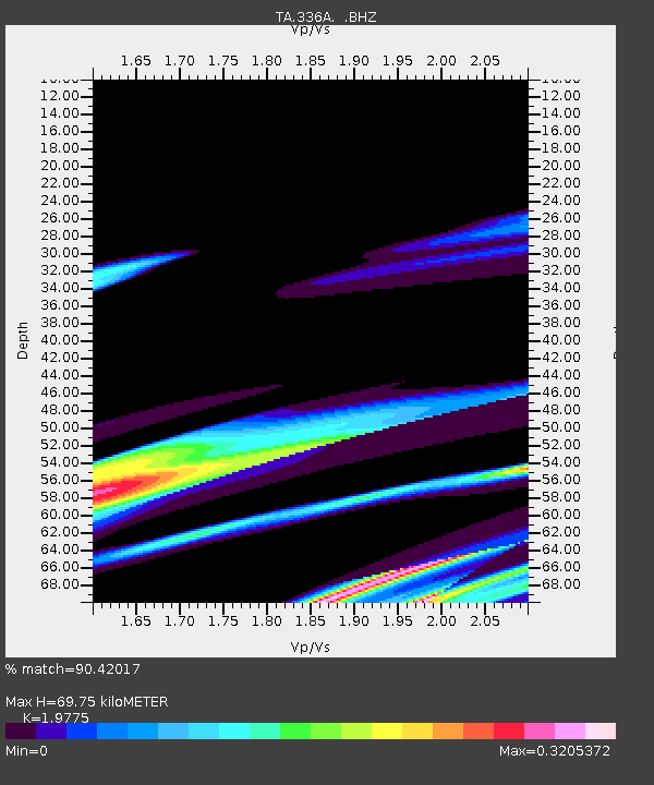
| Estimated Moho Depth: |
69.75 km |
| Estimated Crust Vp/Vs: |
1.98 |
| Assumed Crust Vp: |
6.347 km/s |
| Estimated Crust Vs: |
3.21 km/s |
| Estimated Crust Poisson's Ratio: |
0.33 |
|
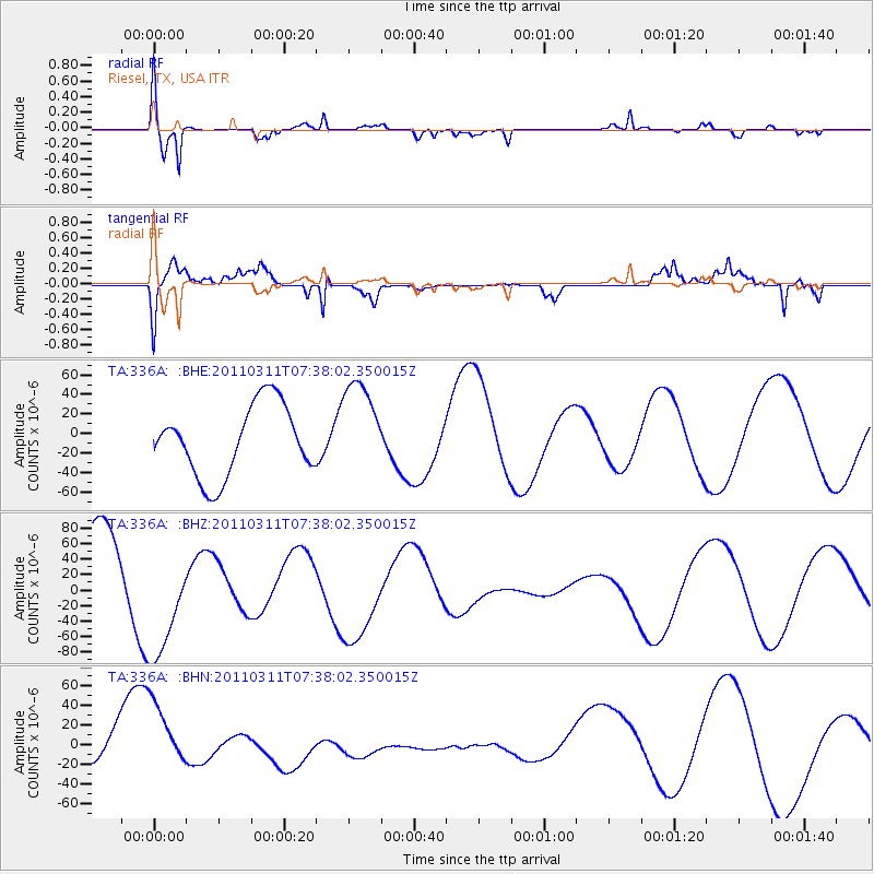
| Radial Match: |
90.42017 % |
| Radial Bump: |
400 |
| Transverse Match: |
67.9326 % |
| Transverse Bump: |
400 |
| SOD ConfigId: |
356183 |
| Insert Time: |
2011-08-12 04:33:38.618 +0000 |
| GWidth: |
2.5 |
| Max Bumps: |
400 |
| Tol: |
0.001 |
|
Signal To Noise
| Channel | StoN | STA | LTA |
| TA:336A: :BHZ:20110311T07:38:02.350015Z | 1.3899944 | 7.277426E-5 | 5.235579E-5 |
| TA:336A: :BHN:20110311T07:38:02.350015Z | 1.8766468 | 4.1199946E-5 | 2.1954023E-5 |
| TA:336A: :BHE:20110311T07:38:02.350015Z | 1.3626888 | 4.9077913E-5 | 3.6015495E-5 |
| Arrivals |
| Ps | 11 SECOND |
| PpPs | 32 SECOND |
| PsPs/PpSs | 43 SECOND |


