You are here: Home > Network List > TA - USArray Transportable Network (new EarthScope stations) Stations List
> Station A32A Rocking H Ranch, Lancaster, MN, USA > Earthquake Result Viewer
A32A Rocking H Ranch, Lancaster, MN, USA - Earthquake Result Viewer

| Earthquake location: |
Off East Coast Of Honshu, Japan |
| Earthquake latitude/longitude: |
37.9/144.5 |
| Earthquake time(UTC): |
2011/03/11 (070) 07:25:36 GMT |
| Earthquake Depth: |
40 km |
| Earthquake Magnitude: |
6.1 MB |
| Earthquake Catalog/Contributor: |
WHDF/NEIC |
|
| Network: |
TA USArray Transportable Network (new EarthScope stations) |
| Station: |
A32A Rocking H Ranch, Lancaster, MN, USA |
| Lat/Lon: |
48.92 N/96.49 W |
| Elevation: |
322 m |
|
| Distance: |
78.0 deg |
| Az: |
36.15 deg |
| Baz: |
315.0 deg |
| Ray Param: |
0.049856912 |
| Estimated Moho Depth: |
29.25 km |
| Estimated Crust Vp/Vs: |
2.10 |
| Assumed Crust Vp: |
6.498 km/s |
| Estimated Crust Vs: |
3.098 km/s |
| Estimated Crust Poisson's Ratio: |
0.35 |
|
| Radial Match: |
80.89339 % |
| Radial Bump: |
400 |
| Transverse Match: |
65.180984 % |
| Transverse Bump: |
400 |
| SOD ConfigId: |
356183 |
| Insert Time: |
2011-08-12 04:54:49.656 +0000 |
| GWidth: |
2.5 |
| Max Bumps: |
400 |
| Tol: |
0.001 |
|
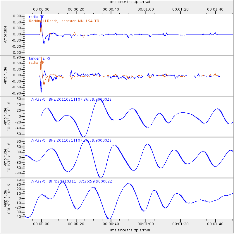
Signal To Noise
| Channel | StoN | STA | LTA |
| TA:A32A: :BHZ:20110311T07:36:59.900002Z | 0.9683745 | 2.9516521E-5 | 3.0480482E-5 |
| TA:A32A: :BHN:20110311T07:36:59.900002Z | 0.48931575 | 1.3308151E-5 | 2.7197473E-5 |
| TA:A32A: :BHE:20110311T07:36:59.900002Z | 2.085139 | 5.4825734E-5 | 2.6293563E-5 |
| Arrivals |
| Ps | 5.1 SECOND |
| PpPs | 14 SECOND |
| PsPs/PpSs | 19 SECOND |


