You are here: Home > Network List > UW - Pacific Northwest Regional Seismic Network Stations List
> Station HOOD Mt Hood Meadows, OR CREST BB SMO > Earthquake Result Viewer
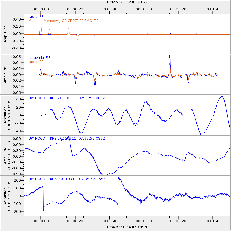
HOOD Mt Hood Meadows, OR CREST BB SMO - Earthquake Result Viewer
*The percent match for this event was below the threshold and hence no stack was calculated.
| Earthquake location: |
Off East Coast Of Honshu, Japan |
| Earthquake latitude/longitude: |
37.9/144.5 |
| Earthquake time(UTC): |
2011/03/11 (070) 07:25:36 GMT |
| Earthquake Depth: |
40 km |
| Earthquake Magnitude: |
6.1 MB |
| Earthquake Catalog/Contributor: |
WHDF/NEIC |
|
| Network: |
UW Pacific Northwest Regional Seismic Network |
| Station: |
HOOD Mt Hood Meadows, OR CREST BB SMO |
| Lat/Lon: |
45.32 N/121.65 W |
| Elevation: |
1520 m |
|
| Distance: |
66.6 deg |
| Az: |
50.074 deg |
| Baz: |
300.741 deg |
| Ray Param: |
$rayparam |
*The percent match for this event was below the threshold and hence was not used in the summary stack. |
|
| Radial Match: |
58.322773 % |
| Radial Bump: |
306 |
| Transverse Match: |
67.18962 % |
| Transverse Bump: |
358 |
| SOD ConfigId: |
356183 |
| Insert Time: |
2011-08-12 05:09:44.528 +0000 |
| GWidth: |
2.5 |
| Max Bumps: |
400 |
| Tol: |
0.001 |
|
Signal To Noise
| Channel | StoN | STA | LTA |
| UW:HOOD: :BHZ:20110311T07:35:52.085Z | 0.99199957 | 0.0011858554 | 0.0011954192 |
| UW:HOOD: :BHN:20110311T07:35:52.085Z | 7.4783025 | 1.2625755E-4 | 1.6883185E-5 |
| UW:HOOD: :BHE:20110311T07:35:52.085Z | 0.64307797 | 1.2380224E-5 | 1.9251513E-5 |
| Arrivals |
| Ps | |
| PpPs | |
| PsPs/PpSs | |


