You are here: Home > Network List > TA - USArray Transportable Network (new EarthScope stations) Stations List
> Station K22A Casper, WY, USA > Earthquake Result Viewer
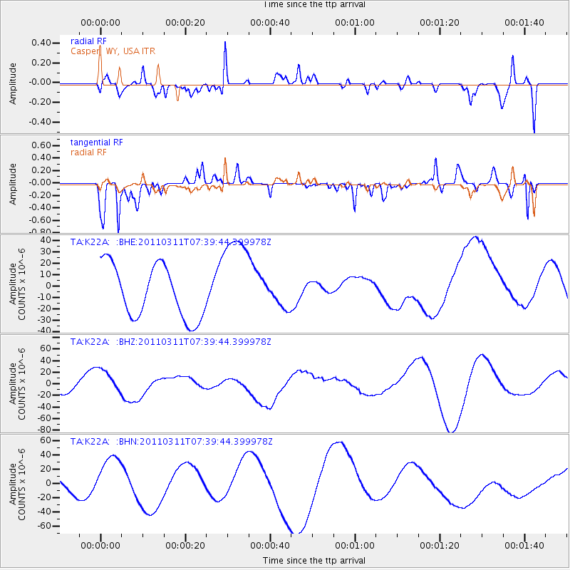
K22A Casper, WY, USA - Earthquake Result Viewer
*The percent match for this event was below the threshold and hence no stack was calculated.
| Earthquake location: |
Near East Coast Of Honshu, Japan |
| Earthquake latitude/longitude: |
36.8/141.8 |
| Earthquake time(UTC): |
2011/03/11 (070) 07:28:12 GMT |
| Earthquake Depth: |
28 km |
| Earthquake Magnitude: |
6.1 MB |
| Earthquake Catalog/Contributor: |
WHDF/NEIC |
|
| Network: |
TA USArray Transportable Network (new EarthScope stations) |
| Station: |
K22A Casper, WY, USA |
| Lat/Lon: |
42.65 N/106.52 W |
| Elevation: |
1686 m |
|
| Distance: |
79.4 deg |
| Az: |
44.241 deg |
| Baz: |
310.64 deg |
| Ray Param: |
$rayparam |
*The percent match for this event was below the threshold and hence was not used in the summary stack. |
|
| Radial Match: |
54.50152 % |
| Radial Bump: |
400 |
| Transverse Match: |
68.43881 % |
| Transverse Bump: |
325 |
| SOD ConfigId: |
356183 |
| Insert Time: |
2011-08-12 06:13:17.333 +0000 |
| GWidth: |
2.5 |
| Max Bumps: |
400 |
| Tol: |
0.001 |
|
Signal To Noise
| Channel | StoN | STA | LTA |
| TA:K22A: :BHZ:20110311T07:39:44.399978Z | 2.0320995 | 2.334684E-5 | 1.1489024E-5 |
| TA:K22A: :BHN:20110311T07:39:44.399978Z | 1.5202883 | 2.8988716E-5 | 1.9067906E-5 |
| TA:K22A: :BHE:20110311T07:39:44.399978Z | 1.8310916 | 4.2053343E-5 | 2.296627E-5 |
| Arrivals |
| Ps | |
| PpPs | |
| PsPs/PpSs | |


