You are here: Home > Network List > TA - USArray Transportable Network (new EarthScope stations) Stations List
> Station G65A Princeton, ME, USA > Earthquake Result Viewer
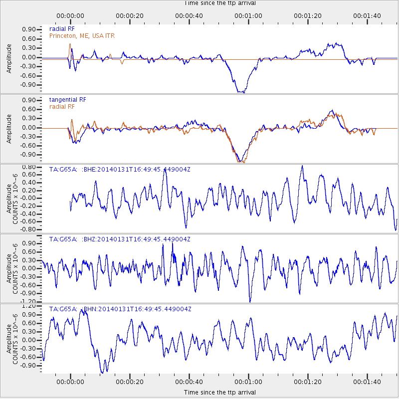
G65A Princeton, ME, USA - Earthquake Result Viewer
*The percent match for this event was below the threshold and hence no stack was calculated.
| Earthquake location: |
Near East Coast Of Kamchatka |
| Earthquake latitude/longitude: |
54.6/159.7 |
| Earthquake time(UTC): |
2014/01/31 (031) 16:39:06 GMT |
| Earthquake Depth: |
168 km |
| Earthquake Magnitude: |
5.5 MW |
| Earthquake Catalog/Contributor: |
ISC/ISC |
|
| Network: |
TA USArray Transportable Network (new EarthScope stations) |
| Station: |
G65A Princeton, ME, USA |
| Lat/Lon: |
45.20 N/67.56 W |
| Elevation: |
78 m |
|
| Distance: |
72.8 deg |
| Az: |
32.929 deg |
| Baz: |
333.445 deg |
| Ray Param: |
$rayparam |
*The percent match for this event was below the threshold and hence was not used in the summary stack. |
|
| Radial Match: |
44.86458 % |
| Radial Bump: |
400 |
| Transverse Match: |
38.298553 % |
| Transverse Bump: |
400 |
| SOD ConfigId: |
3390531 |
| Insert Time: |
2019-04-10 04:24:01.711 +0000 |
| GWidth: |
2.5 |
| Max Bumps: |
400 |
| Tol: |
0.001 |
|
Signal To Noise
| Channel | StoN | STA | LTA |
| TA:G65A: :BHZ:20140131T16:49:45.449004Z | 0.7308071 | 2.3040194E-7 | 3.152705E-7 |
| TA:G65A: :BHN:20140131T16:49:45.449004Z | 1.7883292 | 1.2417538E-6 | 6.943653E-7 |
| TA:G65A: :BHE:20140131T16:49:45.449004Z | 1.9643415 | 3.8276454E-7 | 1.9485641E-7 |
| Arrivals |
| Ps | |
| PpPs | |
| PsPs/PpSs | |


