You are here: Home > Network List > TA - USArray Transportable Network (new EarthScope stations) Stations List
> Station K30A Basset, NE, USA > Earthquake Result Viewer
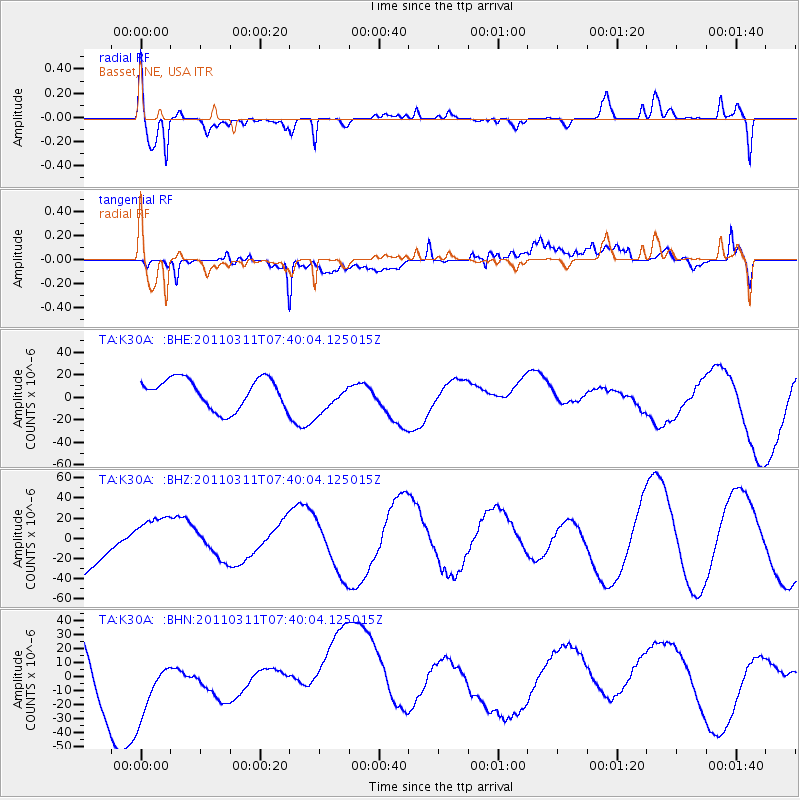
K30A Basset, NE, USA - Earthquake Result Viewer
*The percent match for this event was below the threshold and hence no stack was calculated.
| Earthquake location: |
Near East Coast Of Honshu, Japan |
| Earthquake latitude/longitude: |
36.8/141.8 |
| Earthquake time(UTC): |
2011/03/11 (070) 07:28:12 GMT |
| Earthquake Depth: |
28 km |
| Earthquake Magnitude: |
6.1 MB |
| Earthquake Catalog/Contributor: |
WHDF/NEIC |
|
| Network: |
TA USArray Transportable Network (new EarthScope stations) |
| Station: |
K30A Basset, NE, USA |
| Lat/Lon: |
42.67 N/99.61 W |
| Elevation: |
712 m |
|
| Distance: |
83.1 deg |
| Az: |
40.727 deg |
| Baz: |
314.774 deg |
| Ray Param: |
$rayparam |
*The percent match for this event was below the threshold and hence was not used in the summary stack. |
|
| Radial Match: |
48.861107 % |
| Radial Bump: |
381 |
| Transverse Match: |
55.8938 % |
| Transverse Bump: |
400 |
| SOD ConfigId: |
356183 |
| Insert Time: |
2011-08-12 06:23:14.006 +0000 |
| GWidth: |
2.5 |
| Max Bumps: |
400 |
| Tol: |
0.001 |
|
Signal To Noise
| Channel | StoN | STA | LTA |
| TA:K30A: :BHZ:20110311T07:40:04.125015Z | 0.8253193 | 2.4319077E-5 | 2.9466266E-5 |
| TA:K30A: :BHN:20110311T07:40:04.125015Z | 0.7210768 | 2.4559968E-5 | 3.406013E-5 |
| TA:K30A: :BHE:20110311T07:40:04.125015Z | 1.0345023 | 1.36366725E-5 | 1.3181868E-5 |
| Arrivals |
| Ps | |
| PpPs | |
| PsPs/PpSs | |


