You are here: Home > Network List > TA - USArray Transportable Network (new EarthScope stations) Stations List
> Station S36A Lake Cedric, Chanute, KS, USA > Earthquake Result Viewer
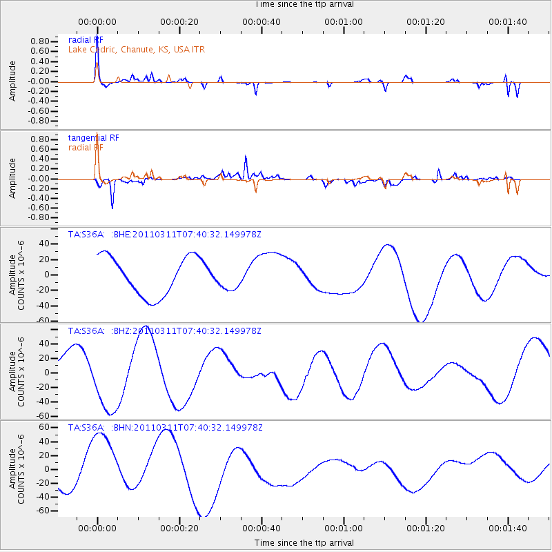
S36A Lake Cedric, Chanute, KS, USA - Earthquake Result Viewer
*The percent match for this event was below the threshold and hence no stack was calculated.
| Earthquake location: |
Near East Coast Of Honshu, Japan |
| Earthquake latitude/longitude: |
36.8/141.8 |
| Earthquake time(UTC): |
2011/03/11 (070) 07:28:12 GMT |
| Earthquake Depth: |
28 km |
| Earthquake Magnitude: |
6.1 MB |
| Earthquake Catalog/Contributor: |
WHDF/NEIC |
|
| Network: |
TA USArray Transportable Network (new EarthScope stations) |
| Station: |
S36A Lake Cedric, Chanute, KS, USA |
| Lat/Lon: |
37.72 N/95.59 W |
| Elevation: |
299 m |
|
| Distance: |
88.8 deg |
| Az: |
41.935 deg |
| Baz: |
317.447 deg |
| Ray Param: |
$rayparam |
*The percent match for this event was below the threshold and hence was not used in the summary stack. |
|
| Radial Match: |
52.19166 % |
| Radial Bump: |
295 |
| Transverse Match: |
69.932846 % |
| Transverse Bump: |
356 |
| SOD ConfigId: |
356183 |
| Insert Time: |
2011-08-12 06:31:25.004 +0000 |
| GWidth: |
2.5 |
| Max Bumps: |
400 |
| Tol: |
0.001 |
|
Signal To Noise
| Channel | StoN | STA | LTA |
| TA:S36A: :BHZ:20110311T07:40:32.149978Z | 1.9768615 | 4.32301E-5 | 2.1868047E-5 |
| TA:S36A: :BHN:20110311T07:40:32.149978Z | 4.0205474 | 5.4280452E-5 | 1.3500762E-5 |
| TA:S36A: :BHE:20110311T07:40:32.149978Z | 0.61305803 | 1.5352956E-5 | 2.5043235E-5 |
| Arrivals |
| Ps | |
| PpPs | |
| PsPs/PpSs | |


