You are here: Home > Network List > TA - USArray Transportable Network (new EarthScope stations) Stations List
> Station K33A Hardington, NE, USA > Earthquake Result Viewer
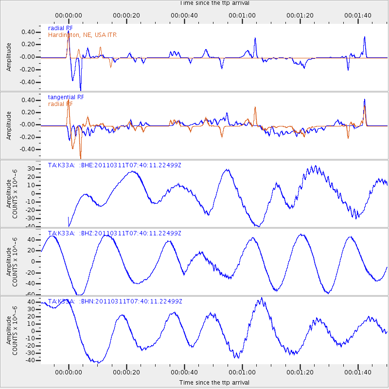
K33A Hardington, NE, USA - Earthquake Result Viewer
*The percent match for this event was below the threshold and hence no stack was calculated.
| Earthquake location: |
Near East Coast Of Honshu, Japan |
| Earthquake latitude/longitude: |
36.8/141.8 |
| Earthquake time(UTC): |
2011/03/11 (070) 07:28:12 GMT |
| Earthquake Depth: |
28 km |
| Earthquake Magnitude: |
6.1 MB |
| Earthquake Catalog/Contributor: |
WHDF/NEIC |
|
| Network: |
TA USArray Transportable Network (new EarthScope stations) |
| Station: |
K33A Hardington, NE, USA |
| Lat/Lon: |
42.61 N/97.00 W |
| Elevation: |
507 m |
|
| Distance: |
84.5 deg |
| Az: |
39.39 deg |
| Baz: |
316.392 deg |
| Ray Param: |
$rayparam |
*The percent match for this event was below the threshold and hence was not used in the summary stack. |
|
| Radial Match: |
73.02199 % |
| Radial Bump: |
400 |
| Transverse Match: |
34.053875 % |
| Transverse Bump: |
400 |
| SOD ConfigId: |
356183 |
| Insert Time: |
2011-08-12 06:38:14.431 +0000 |
| GWidth: |
2.5 |
| Max Bumps: |
400 |
| Tol: |
0.001 |
|
Signal To Noise
| Channel | StoN | STA | LTA |
| TA:K33A: :BHZ:20110311T07:40:11.22499Z | 1.8279233 | 4.994532E-5 | 2.7323531E-5 |
| TA:K33A: :BHN:20110311T07:40:11.22499Z | 1.1362687 | 3.056266E-5 | 2.6897387E-5 |
| TA:K33A: :BHE:20110311T07:40:11.22499Z | 0.4848177 | 8.375207E-6 | 1.7274959E-5 |
| Arrivals |
| Ps | |
| PpPs | |
| PsPs/PpSs | |


