You are here: Home > Network List > AZ - ANZA Regional Network Stations List
> Station SOL AZ.SOL > Earthquake Result Viewer
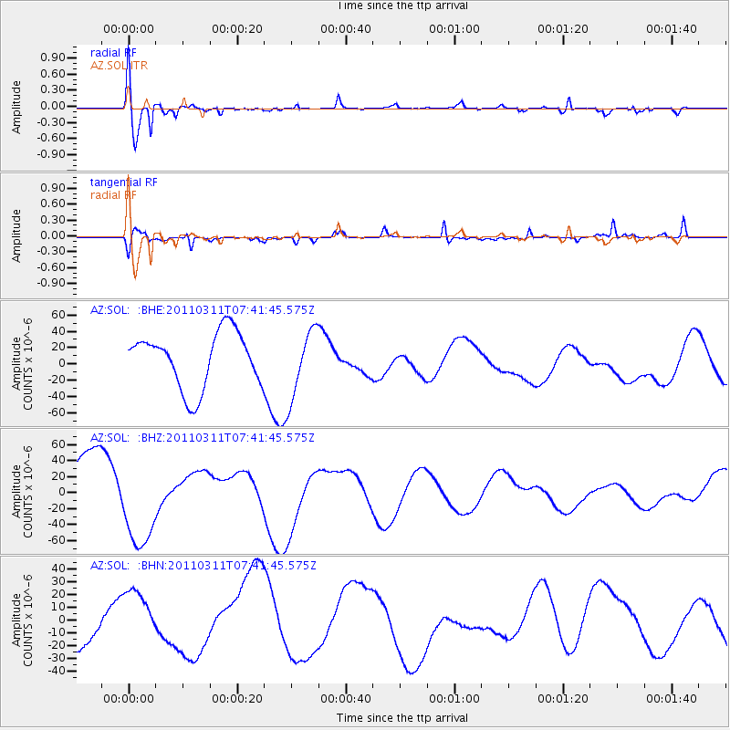
SOL AZ.SOL - Earthquake Result Viewer

| Earthquake location: |
Near East Coast Of Honshu, Japan |
| Earthquake latitude/longitude: |
37.4/141.2 |
| Earthquake time(UTC): |
2011/03/11 (070) 07:30:18 GMT |
| Earthquake Depth: |
49 km |
| Earthquake Magnitude: |
6.0 MB |
| Earthquake Catalog/Contributor: |
WHDF/NEIC |
|
| Network: |
AZ ANZA Regional Network |
| Station: |
SOL AZ.SOL |
| Lat/Lon: |
32.84 N/117.25 W |
| Elevation: |
245 m |
|
| Distance: |
78.9 deg |
| Az: |
57.192 deg |
| Baz: |
307.377 deg |
| Ray Param: |
0.049240883 |
| Estimated Moho Depth: |
64.25 km |
| Estimated Crust Vp/Vs: |
2.10 |
| Assumed Crust Vp: |
6.264 km/s |
| Estimated Crust Vs: |
2.986 km/s |
| Estimated Crust Poisson's Ratio: |
0.35 |
|
| Radial Match: |
88.29715 % |
| Radial Bump: |
400 |
| Transverse Match: |
63.381134 % |
| Transverse Bump: |
325 |
| SOD ConfigId: |
356183 |
| Insert Time: |
2011-08-12 09:04:15.231 +0000 |
| GWidth: |
2.5 |
| Max Bumps: |
400 |
| Tol: |
0.001 |
|
Signal To Noise
| Channel | StoN | STA | LTA |
| AZ:SOL: :BHZ:20110311T07:41:45.575Z | 1.3492161 | 5.7862693E-5 | 4.2886157E-5 |
| AZ:SOL: :BHN:20110311T07:41:45.575Z | 1.7614149 | 2.5324485E-5 | 1.4377354E-5 |
| AZ:SOL: :BHE:20110311T07:41:45.575Z | 1.2486805 | 4.2189804E-5 | 3.378751E-5 |
| Arrivals |
| Ps | 12 SECOND |
| PpPs | 31 SECOND |
| PsPs/PpSs | 43 SECOND |


