You are here: Home > Network List > CI - Caltech Regional Seismic Network Stations List
> Station BAR Barrett, Tecate, CA, USA > Earthquake Result Viewer
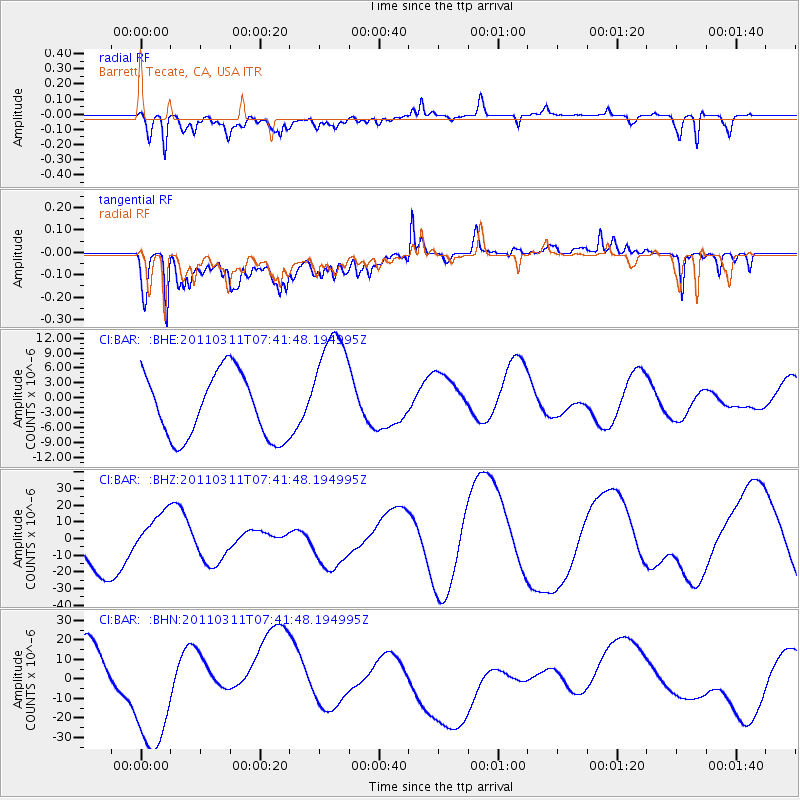
BAR Barrett, Tecate, CA, USA - Earthquake Result Viewer
*The percent match for this event was below the threshold and hence no stack was calculated.
| Earthquake location: |
Near East Coast Of Honshu, Japan |
| Earthquake latitude/longitude: |
37.4/141.2 |
| Earthquake time(UTC): |
2011/03/11 (070) 07:30:18 GMT |
| Earthquake Depth: |
49 km |
| Earthquake Magnitude: |
6.0 MB |
| Earthquake Catalog/Contributor: |
WHDF/NEIC |
|
| Network: |
CI Caltech Regional Seismic Network |
| Station: |
BAR Barrett, Tecate, CA, USA |
| Lat/Lon: |
32.68 N/116.67 W |
| Elevation: |
521 m |
|
| Distance: |
79.4 deg |
| Az: |
57.02 deg |
| Baz: |
307.655 deg |
| Ray Param: |
$rayparam |
*The percent match for this event was below the threshold and hence was not used in the summary stack. |
|
| Radial Match: |
46.041817 % |
| Radial Bump: |
400 |
| Transverse Match: |
56.645348 % |
| Transverse Bump: |
400 |
| SOD ConfigId: |
356183 |
| Insert Time: |
2011-08-12 09:07:28.588 +0000 |
| GWidth: |
2.5 |
| Max Bumps: |
400 |
| Tol: |
0.001 |
|
Signal To Noise
| Channel | StoN | STA | LTA |
| CI:BAR: :BHZ:20110311T07:41:48.194995Z | 0.86351323 | 1.2927342E-5 | 1.4970636E-5 |
| CI:BAR: :BHN:20110311T07:41:48.194995Z | 1.6379015 | 2.593532E-5 | 1.5834481E-5 |
| CI:BAR: :BHE:20110311T07:41:48.194995Z | 1.8731492 | 1.2168131E-5 | 6.4960823E-6 |
| Arrivals |
| Ps | |
| PpPs | |
| PsPs/PpSs | |


