You are here: Home > Network List > TA - USArray Transportable Network (new EarthScope stations) Stations List
> Station R28A Tribune, KS, USA > Earthquake Result Viewer
R28A Tribune, KS, USA - Earthquake Result Viewer
| Earthquake location: |
Near East Coast Of Honshu, Japan |
| Earthquake latitude/longitude: |
37.4/141.2 |
| Earthquake time(UTC): |
2011/03/11 (070) 07:30:18 GMT |
| Earthquake Depth: |
49 km |
| Earthquake Magnitude: |
6.0 MB |
| Earthquake Catalog/Contributor: |
WHDF/NEIC |
|
| Network: |
TA USArray Transportable Network (new EarthScope stations) |
| Station: |
R28A Tribune, KS, USA |
| Lat/Lon: |
38.34 N/101.81 W |
| Elevation: |
1108 m |
|
| Distance: |
84.8 deg |
| Az: |
44.71 deg |
| Baz: |
314.594 deg |
| Ray Param: |
0.045109347 |
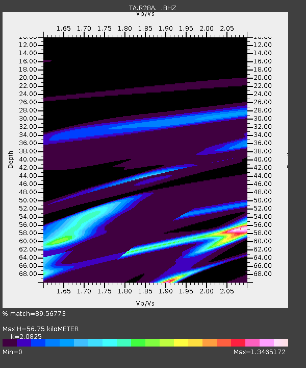
| Estimated Moho Depth: |
56.75 km |
| Estimated Crust Vp/Vs: |
2.08 |
| Assumed Crust Vp: |
6.483 km/s |
| Estimated Crust Vs: |
3.113 km/s |
| Estimated Crust Poisson's Ratio: |
0.35 |
|
| Radial Match: |
89.56773 % |
| Radial Bump: |
336 |
| Transverse Match: |
60.213467 % |
| Transverse Bump: |
400 |
| SOD ConfigId: |
356183 |
| Insert Time: |
2011-08-12 09:40:47.415 +0000 |
| GWidth: |
2.5 |
| Max Bumps: |
400 |
| Tol: |
0.001 |
|

Signal To Noise
| Channel | StoN | STA | LTA |
| TA:R28A: :BHZ:20110311T07:42:16.650012Z | 0.33342943 | 1.1833518E-5 | 3.5490324E-5 |
| TA:R28A: :BHN:20110311T07:42:16.650012Z | 2.321973 | 4.1639283E-5 | 1.7932716E-5 |
| TA:R28A: :BHE:20110311T07:42:16.650012Z | 0.3718902 | 8.858254E-6 | 2.381954E-5 |
| Arrivals |
| Ps | 9.7 SECOND |
| PpPs | 26 SECOND |
| PsPs/PpSs | 36 SECOND |


