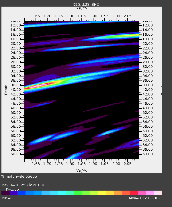
LL23 Sali PS - Earthquake Result Viewer

Earthquake location: South Sandwich Islands Region
Earthquake latitude/longitude: -56.8/-27.3
Earthquake time(UTC): 2014/02/01 (032) 03:58:43 GMT
Earthquake Depth: 130 km
Earthquake Magnitude: 6.1 MWW, 6.1 MWC, 6.1 MWB, 6.2 MWC
Earthquake Catalog/Contributor: NEIC PDE/NEIC COMCAT
Network: XJ CRAFTI
Station: LL23 Sali PS
Lat/Lon: 2.30 S/35.69 E
Elevation: 1257 m
Distance: 73.6 deg
Az: 68.173 deg
Baz: 210.713 deg
Ray Param: 0.052569944
Estimated Moho Depth: 38.25 km
Estimated Crust Vp/Vs: 1.65
Assumed Crust Vp: 6.576 km/s
Estimated Crust Vs: 3.986 km/s
Estimated Crust Poisson's Ratio: 0.21
Radial Match: 86.05655 %
Radial Bump: 400
Transverse Match: 63.681026 %
Transverse Bump: 400
SOD ConfigId: 3390531
Insert Time: 2019-04-10 04:29:41.328 +0000
GWidth: 2.5
Max Bumps: 400
Tol: 0.001

Signal To Noise

ChannelStoNSTALTA
XJ:LL23: :BHZ:20140201T04:09:31.959971Z4.51520254.151989E-79.195577E-8
XJ:LL23: :BHN:20140201T04:09:31.959971Z2.04461.2306664E-76.0191056E-8
XJ:LL23: :BHE:20140201T04:09:31.959971Z1.65223688.1116525E-84.9094975E-8
Arrivals
Ps3.9 SECOND
PpPs15 SECOND
PsPs/PpSs19 SECOND