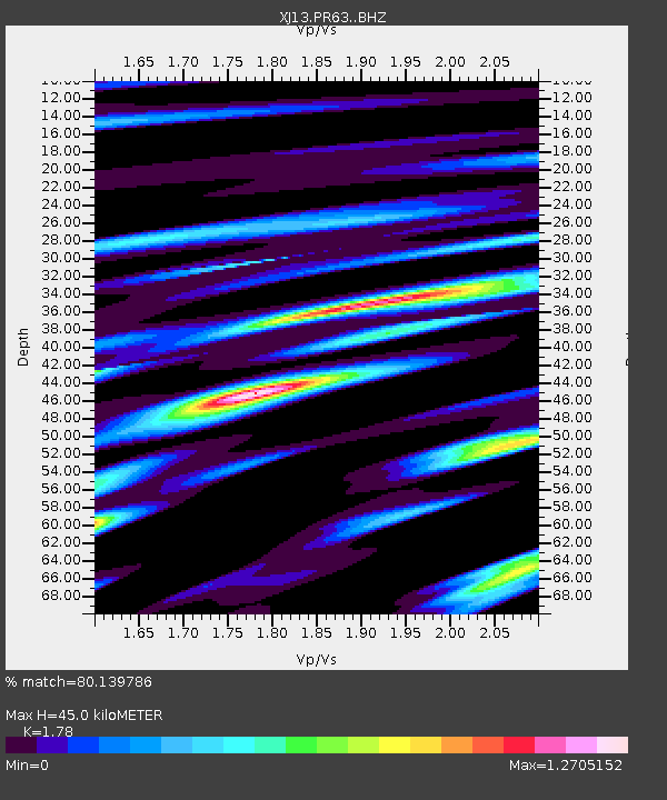
PR63 Meshili Boma - Earthquake Result Viewer

Earthquake location: South Sandwich Islands Region
Earthquake latitude/longitude: -56.8/-27.3
Earthquake time(UTC): 2014/02/01 (032) 03:58:43 GMT
Earthquake Depth: 130 km
Earthquake Magnitude: 6.1 MWW, 6.1 MWC, 6.1 MWB, 6.2 MWC
Earthquake Catalog/Contributor: NEIC PDE/NEIC COMCAT
Network: XJ CRAFTI
Station: PR63 Meshili Boma
Lat/Lon: 2.99 S/35.51 E
Elevation: 1362 m
Distance: 72.9 deg
Az: 68.378 deg
Baz: 210.781 deg
Ray Param: 0.053027067
Estimated Moho Depth: 45.0 km
Estimated Crust Vp/Vs: 1.78
Assumed Crust Vp: 6.576 km/s
Estimated Crust Vs: 3.695 km/s
Estimated Crust Poisson's Ratio: 0.27
Radial Match: 80.139786 %
Radial Bump: 400
Transverse Match: 71.20867 %
Transverse Bump: 400
SOD ConfigId: 3390531
Insert Time: 2019-04-10 04:29:50.977 +0000
GWidth: 2.5
Max Bumps: 400
Tol: 0.001

Signal To Noise

ChannelStoNSTALTA
XJ:PR63: :BHZ:20140201T04:09:27.940012Z8.4432388.066323E-79.553589E-8
XJ:PR63: :BHN:20140201T04:09:27.940012Z2.23378251.9564716E-78.758559E-8
XJ:PR63: :BHE:20140201T04:09:27.940012Z0.91048031.061646E-71.1660285E-7
Arrivals
Ps5.5 SECOND
PpPs18 SECOND
PsPs/PpSs24 SECOND