You are here: Home > Network List > TA - USArray Transportable Network (new EarthScope stations) Stations List
> Station W36A Wetumka, OK, USA > Earthquake Result Viewer
W36A Wetumka, OK, USA - Earthquake Result Viewer
| Earthquake location: |
Near East Coast Of Honshu, Japan |
| Earthquake latitude/longitude: |
37.4/141.2 |
| Earthquake time(UTC): |
2011/03/11 (070) 07:30:18 GMT |
| Earthquake Depth: |
49 km |
| Earthquake Magnitude: |
6.0 MB |
| Earthquake Catalog/Contributor: |
WHDF/NEIC |
|
| Network: |
TA USArray Transportable Network (new EarthScope stations) |
| Station: |
W36A Wetumka, OK, USA |
| Lat/Lon: |
35.14 N/96.23 W |
| Elevation: |
251 m |
|
| Distance: |
90.3 deg |
| Az: |
43.679 deg |
| Baz: |
317.879 deg |
| Ray Param: |
0.041679114 |
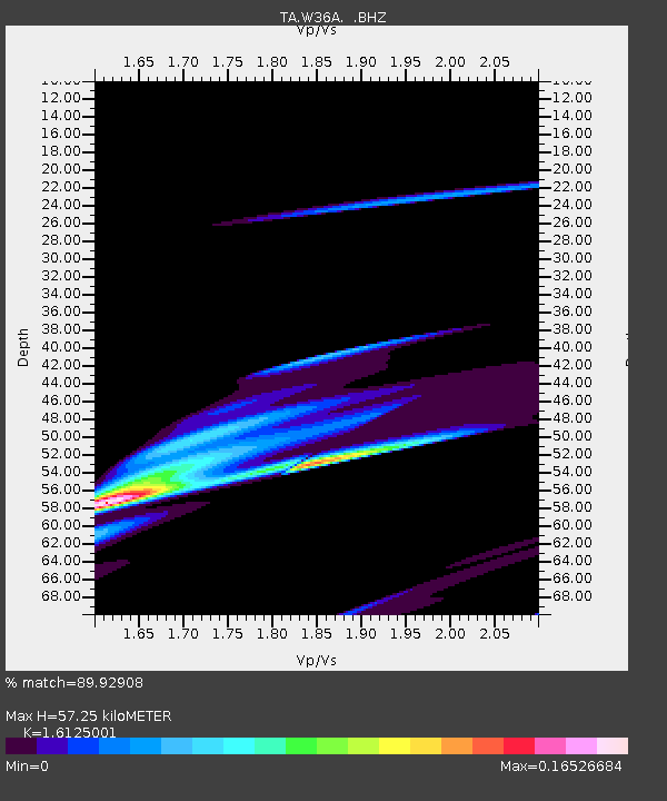
| Estimated Moho Depth: |
57.25 km |
| Estimated Crust Vp/Vs: |
1.61 |
| Assumed Crust Vp: |
6.426 km/s |
| Estimated Crust Vs: |
3.985 km/s |
| Estimated Crust Poisson's Ratio: |
0.19 |
|
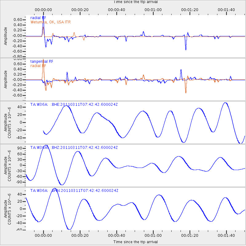
| Radial Match: |
89.92908 % |
| Radial Bump: |
400 |
| Transverse Match: |
79.78008 % |
| Transverse Bump: |
392 |
| SOD ConfigId: |
356183 |
| Insert Time: |
2011-08-12 09:59:50.506 +0000 |
| GWidth: |
2.5 |
| Max Bumps: |
400 |
| Tol: |
0.001 |
|
Signal To Noise
| Channel | StoN | STA | LTA |
| TA:W36A: :BHZ:20110311T07:42:42.600024Z | 2.4546382 | 9.833558E-5 | 4.0061128E-5 |
| TA:W36A: :BHN:20110311T07:42:42.600024Z | 1.1171457 | 2.715195E-5 | 2.4304754E-5 |
| TA:W36A: :BHE:20110311T07:42:42.600024Z | 0.6660409 | 1.7110317E-5 | 2.568959E-5 |
| Arrivals |
| Ps | 5.6 SECOND |
| PpPs | 23 SECOND |
| PsPs/PpSs | 28 SECOND |


