You are here: Home > Network List > TA - USArray Transportable Network (new EarthScope stations) Stations List
> Station L35A Bielow Farm, Ricketts, IA, USA > Earthquake Result Viewer
L35A Bielow Farm, Ricketts, IA, USA - Earthquake Result Viewer

| Earthquake location: |
Near East Coast Of Honshu, Japan |
| Earthquake latitude/longitude: |
37.4/141.2 |
| Earthquake time(UTC): |
2011/03/11 (070) 07:30:18 GMT |
| Earthquake Depth: |
49 km |
| Earthquake Magnitude: |
6.0 MB |
| Earthquake Catalog/Contributor: |
WHDF/NEIC |
|
| Network: |
TA USArray Transportable Network (new EarthScope stations) |
| Station: |
L35A Bielow Farm, Ricketts, IA, USA |
| Lat/Lon: |
42.11 N/95.54 W |
| Elevation: |
410 m |
|
| Distance: |
85.4 deg |
| Az: |
38.621 deg |
| Baz: |
318.112 deg |
| Ray Param: |
0.044686362 |
| Estimated Moho Depth: |
59.25 km |
| Estimated Crust Vp/Vs: |
2.03 |
| Assumed Crust Vp: |
6.53 km/s |
| Estimated Crust Vs: |
3.213 km/s |
| Estimated Crust Poisson's Ratio: |
0.34 |
|
| Radial Match: |
80.98082 % |
| Radial Bump: |
400 |
| Transverse Match: |
59.595203 % |
| Transverse Bump: |
400 |
| SOD ConfigId: |
356183 |
| Insert Time: |
2011-08-12 10:04:09.143 +0000 |
| GWidth: |
2.5 |
| Max Bumps: |
400 |
| Tol: |
0.001 |
|
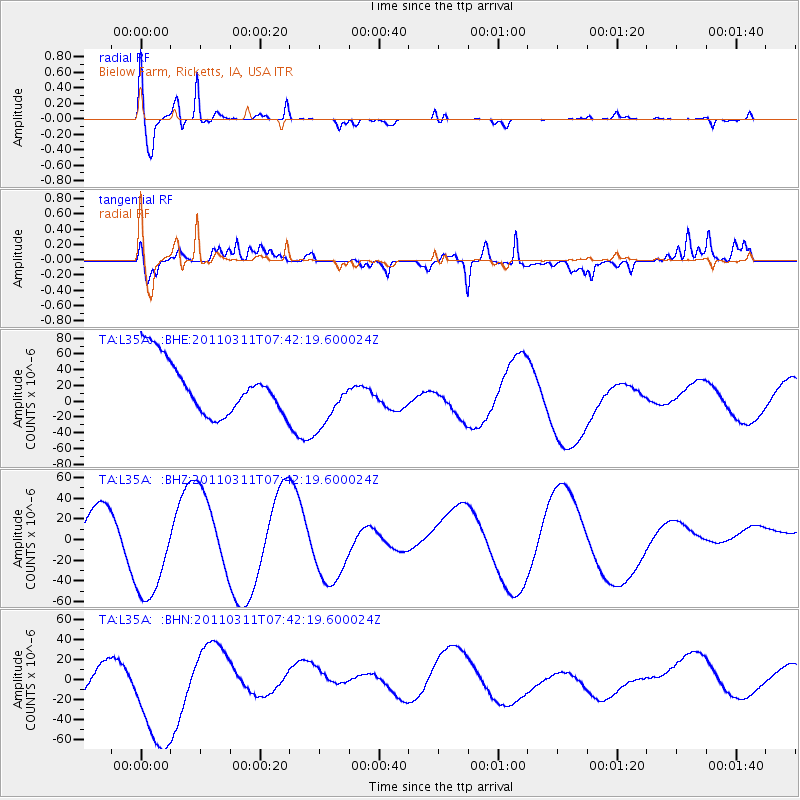
Signal To Noise
| Channel | StoN | STA | LTA |
| TA:L35A: :BHZ:20110311T07:42:19.600024Z | 1.6762228 | 4.6650715E-5 | 2.7830856E-5 |
| TA:L35A: :BHN:20110311T07:42:19.600024Z | 1.9367034 | 6.815152E-5 | 3.5189445E-5 |
| TA:L35A: :BHE:20110311T07:42:19.600024Z | 1.0937806 | 3.6875594E-5 | 3.3713884E-5 |
| Arrivals |
| Ps | 9.6 SECOND |
| PpPs | 27 SECOND |
| PsPs/PpSs | 36 SECOND |


