You are here: Home > Network List > TA - USArray Transportable Network (new EarthScope stations) Stations List
> Station G34A Benson, MN, USA > Earthquake Result Viewer
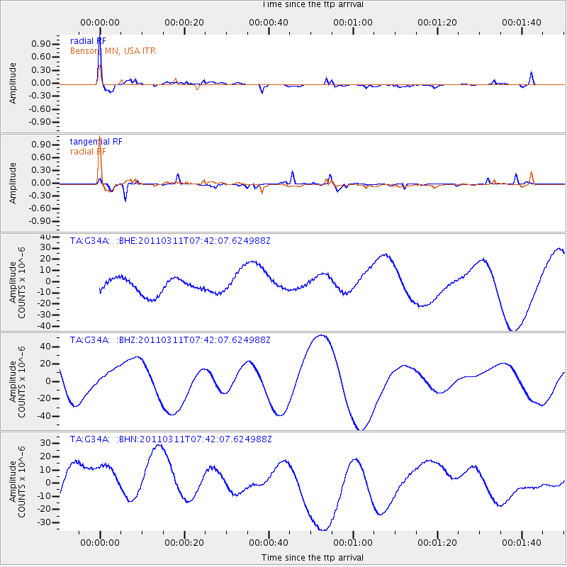
G34A Benson, MN, USA - Earthquake Result Viewer
*The percent match for this event was below the threshold and hence no stack was calculated.
| Earthquake location: |
Near East Coast Of Honshu, Japan |
| Earthquake latitude/longitude: |
37.4/141.2 |
| Earthquake time(UTC): |
2011/03/11 (070) 07:30:18 GMT |
| Earthquake Depth: |
49 km |
| Earthquake Magnitude: |
6.0 MB |
| Earthquake Catalog/Contributor: |
WHDF/NEIC |
|
| Network: |
TA USArray Transportable Network (new EarthScope stations) |
| Station: |
G34A Benson, MN, USA |
| Lat/Lon: |
45.24 N/95.64 W |
| Elevation: |
316 m |
|
| Distance: |
83.1 deg |
| Az: |
36.567 deg |
| Baz: |
317.842 deg |
| Ray Param: |
$rayparam |
*The percent match for this event was below the threshold and hence was not used in the summary stack. |
|
| Radial Match: |
59.04975 % |
| Radial Bump: |
400 |
| Transverse Match: |
64.01398 % |
| Transverse Bump: |
291 |
| SOD ConfigId: |
356183 |
| Insert Time: |
2011-08-12 10:14:16.387 +0000 |
| GWidth: |
2.5 |
| Max Bumps: |
400 |
| Tol: |
0.001 |
|
Signal To Noise
| Channel | StoN | STA | LTA |
| TA:G34A: :BHZ:20110311T07:42:07.624988Z | 0.4389908 | 1.3209078E-5 | 3.0089646E-5 |
| TA:G34A: :BHN:20110311T07:42:07.624988Z | 0.76403457 | 1.9989302E-5 | 2.6162823E-5 |
| TA:G34A: :BHE:20110311T07:42:07.624988Z | 1.7885051 | 1.16474985E-5 | 6.5124214E-6 |
| Arrivals |
| Ps | |
| PpPs | |
| PsPs/PpSs | |


